Traffic Conditions
Introduction
This chapter reviews the traffic characteristics of the M-32 and Old-27 corridor study area. An extensive review of the roadway has been conducted within the study area. The assessment of the traffic within the study area involved the collection of various corridor traffic attributes including speed limits, lanes, traffic control, traffic volumes, and crash history. This section of the Corridor Plan will identify any existing and/or potential operational deficiencies along the project corridor and make recommendations.
Existing Conditions
This is a summary of the existing travel conditions along the M-32 and Old-27 corridors within Otsego County.
Speed Limits
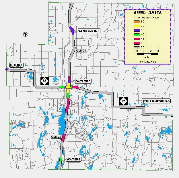
Speed limits are set to match roadway design and area characteristics. Speed limits reflect the safety of a particular roadway and controls access to it. The speed limit along this corridor varies from 25 M.P.H. within the City of Gaylord to 55 M.P.H. in the rural areas throughout Otsego County. The existing corridor speed limits are displayed graphically in Figure 5.1.
Along M-32 traveling west to east, the speed limits change at the following locations:
- 25-35 M.P.H. through Elmira, then
- 55 M.P.H. to Hallock Rd, then45 M.P.H. to Huxtable Rd, then
- 55 M.P.H. to Alba Rd, then
- 45 M.P.H. to Hayes Tower Rd, then
- 55 M.P.H. to Murner Rd, then
- 40 M.P.H. to Wilkinson Rd, then
- 50 M.P.H. to Maple Ridge Ln, then
- 55 M.P.H. to Turtle Lake Rd then
- 30 M.P.H. to Oley Lake Rd, then
- 55 M.P.H. to McCoy Rd, then
- 45 M.P.H. to Havenwood Dr, then
- 55 M.P.H. to Hetherton Rd, then
- 25 M.P.H. to Rowan St, then
- 55 M.P.H. to Finnegan Rd, then
- 35 M.P.H. to Douglas Lake Rd, then
- 55 M.P.H. to Meridian Line Rd
Along Old-27 traveling north to south, the speed limits change at the following locations:
- 55 M.P.H. to Garfield St, then
- 35 M.P.H. to Badgley Rd, then
- 55 M.P.H. to Livingston Rd, then
- 45 M.P.H. to McLouth Rd, then
- 35 M.P.H. to North St, then
- 30 M.P.H. to Wisconsin Blvd, then
- 40 M.P.H. to Charboneau Ln, then
- 50 M.P.H. to Alpine Rd, then
- 55 M.P.H. to Memorial Dr then
- 40 M.P.H. to Marlette Rd, then
- 55 M.P.H. to County line
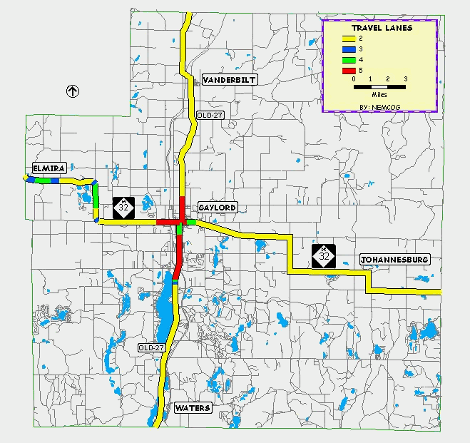
Number of Lanes
The section of the study corridor from the City of Gaylord west to the Otsego County line along M-32 has a varying cross-section containing two to five travel lanes. Three-lane cross-sections are also found on this same stretch of M-32, as well as Old-27, near Otsego Lake. The rest of the study corridor contains mostly two-lane highway cross-sections. These are located north, south, and east of the City of Gaylord. The existing roadway widths are displayed graphically in Figure 5.2.
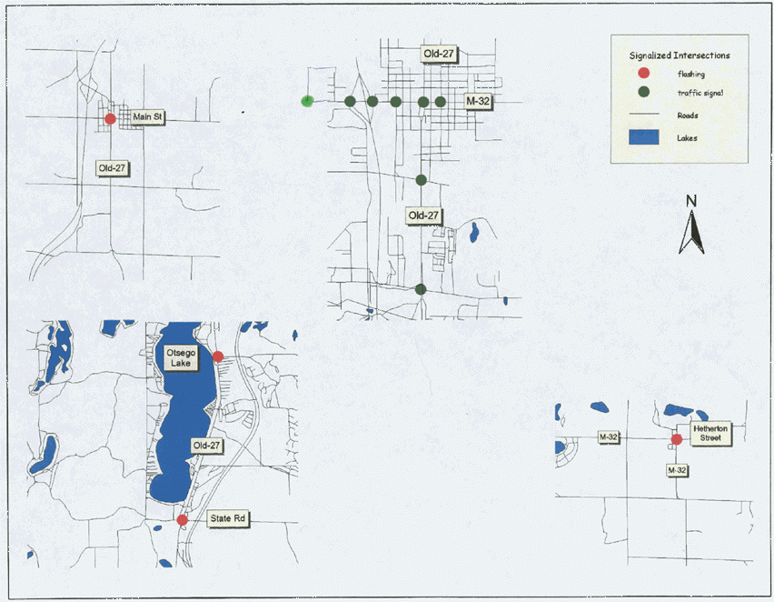
Traffic Control
Upon review of the corridor study area, there are 8 identified intersections that are controlled by traffic signals, and 4 that are controlled by flashing signals. The other
intersections are stop-controlled for the side streets. The majority of the traffic signals are located within the greater Gaylord area. The existing corridor traffic control is displayed in Figure 5.3.
Major Traffic Generators
Areas of development along the corridors that are large generators of traffic were identified. These developments, located primarily in the greater Gaylord area, create a large amount of the traffic that travels along these corridors. Major traffic generators include the industrial/commercial development off Dickerson Road; industrial and commercial development located at the I-75 interchange near Waters; downtown of Gaylord; I-75 interchanges servicing Waters, Gaylord, and Vanderbilt; commercial development both within and adjacent to Gaylord on M-32 west, Old-27 north and south and I-75 Business; the education/governmental complex north of Gaylord on Old-27; Gaylord high school. Residential development within all of the communities, around lakes and within large residential/resort developments such as Michaywe are also traffic generators.
Festival Land Development has proposed building a retail development, named Otsego Place East, in the northeast quadrant of the I-75/Old-27 interchange in Bagley Township. The development, as proposed, will consist of two phases with approximately 944,200 square feet total. The development is expected to be completed within ten years.
Major Traffic Input Locations
Roadways that connect into the corridor study area that are considered major traffic inputs into the transportation network were identified. These were identified according to information supplied by the Otsego County Road Commission. Along M-32, traveling west to east, the following roadways are considered major traffic inputs to the corridor:
- Camp Ten Rd
- Alba Rd
- Hayes Tower Rd
- N Townline Rd
- S Townline Rd
- Murner Rd
- Dickerson Rd
- Wilkinson Rd
- Krys Rd
- Big Lake Rd
- McCoy Rd
- Turtle Lake Rd
- Meridian Line Rd
Along Old-27, traveling north to south, the following roadways are considered major traffic inputs to the corridor:
- Thumb Lake Rd
- East Sturgeon Valley Rd
- Whitmarsh Rd
- Parmater Rd/Poquette Rd
- McCoy Rd
- Johnson Rd
- Mancelona Rd/Old State Rd
- Marlette Rd
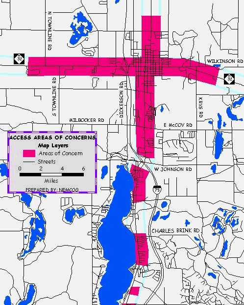
Access Points
Access points, which include driveways and streets, allow for ingress and egress of traffic along the corridor study area. Spacing between access points, particularly those that generate higher volumes of traffic, has a direct correlation with highway safety, travel time and capacity. This section identifies areas of concern along the corridor, where spacing between driveways is less than desirable for posted speed limits on the highway. Local communities have an interest in both managing access in developing segments and in some areas working with property owners to reduce the number of driveways in problem prone areas.
Access points were located on the Otsego County digital ortho-photos. Using Maptitude GIS, the spacing was compared to posted speed limits along the corridor. Areas abuting the corridor containing parcels with small lot widths were also included in the areas of concern. The following areas were identified using the above criteria. M-32 from North Townline Road through Gaylord to Wilkinson Road; Old 27 /North Center Avenue from the Gaylord High School, south to M-32;
Business I-75 from M-32 south to the freeway interchange; Old 27 south from W. Otsego Lake Road to Alpine Road; Old 27 south from Charles Brink Road to Lakeview Street, and the down towns of commercial areas of Vanderbilt, Waters and Johannesburg. With the exception of the Charles Brink Road to Lakeview Street segment, the predominate roadside land uses are commercial and industrial. Other small segments along the corridor were identified as access management areas of concern. While the current zoning and land use is residential, the potential for conversion to commercial exists, particularly when these parcels are adjacent to existing commercial uses. Access to the west off Old 27 from Waters to West Otsego Lake Road is limited due to the Lake State Railroad. Figure 5.4 depicts access areas of concern in the greater Gaylord area.
Figure 5.4
Areas of Concern
Traffic Volumes
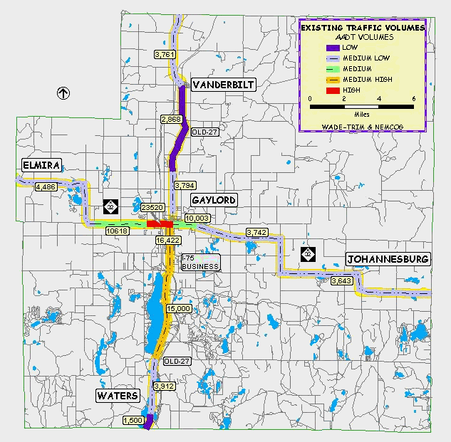
Existing traffic data was compiled from two sources; the Michigan Department of Transportation, and Wade-Trim, Inc. Traffic data was collected in the form of annual average daily traffic volumes (AADT’s) along the study corridors. AADT’s are the average of daily traffic on a road segment for all days of the week over the period of one year. This includes peak travel times during the summer months. The existing annual average daily traffic (AADT) volumes are graphically displayed in Figure 5.5.
Figure 5.5
Existing Traffic Volumes
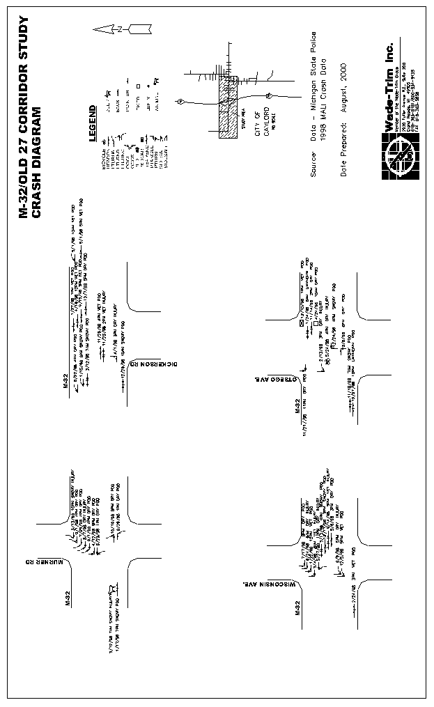
Crashes
Crash data was collected for Otsego County and data not related to the corridor removed. MALI accident data from the calendar year 1998 for the M-32 and the Old-27 corridors, supplied by the Michigan State Police, was used in the study. 1999 data, supplied by the Gaylord City Police Department is available, but was only used to supplement data since it was not available for the entire calendar year. Crash information included crash type, date, time of day, and weather conditions. Crash data was not available for all of the intersections along the corridor.
Based on the crash information received, 104 crashes occurred along the corridor in the calendar year 1998. Of the 104 crashes, no fatal crashes, 23-personal injury crashes, and 81-property damage only crashes occurred.
The crash data indicated four intersections along the corridor where a large number of total studied crashes occurred (greater than 10 crashes per intersection in 1998) all concentrated within and around the City of Gaylord. They are along M-32 at the intersections of Dickerson Road, Wisconsin Avenue, Murner Road, and Otsego Avenue. These intersections experienced 13, 12, 11, and 11 crashes respectively. It should be noted that since this crash data was released, a traffic signal has been installed at the intersection of Murner Road and M-32. The crash diagrams for the above mentioned intersections are displayed in Figure 5.6.
Figure 5.6
Crash Diagram
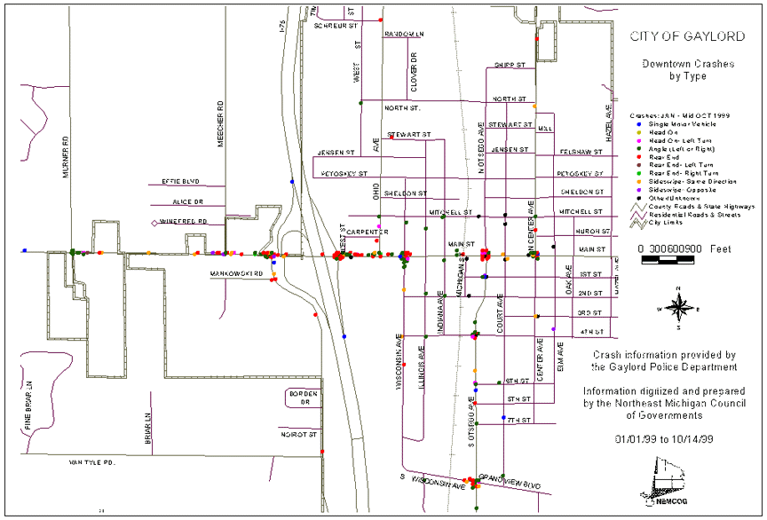
As a follow-up to this plan, either the City of Gaylord or MDOT should complete a more detailed crash analysis for these locations utilizing the UD-10 crash reports. Certain crash patterns can be observed from the 1999 UD-10 reports from January 1999 to mid-October 1999, as mapped
Figure 5.7
City of Gaylord Crash Pattern
Operating Conditions
Currently, the majority of the corridor study area is operating with sufficient reserve capacity. The M-32 corridor through the Gaylord area may have some operating deficiencies, operating at or near capacity. This contributes to the higher level of crashes in this area. According to data collected, including speeds, crashes, and lane widths, we have identified sections that should be examined further. They are:
- M-32 from Meecher Rd to Wisconsin Ave
- Intersection of M-32 and Old-27
- Intersection of Old-27 and Wisconsin Ave/Grandview Blvd
The City of Gaylord, in conjunction with MDOT should conduct more detailed analysis of these intersections and corridors. This would include peak hour turning movement counts, geometric design, and traffic control deficiencies, adjustments, and possible upgrades. Collected data is insufficient on the section of Old-27 directly north of M-32 in the City of Gaylord, to determine operating conditions.
Many options are available to improve the operating conditions of the less productive road segments or intersections. Roundabouts are just one of the possible ways to improve an intersection, since by their design, they act to improve safety by eliminating left turn conflicts and reducing the chance for crashes. Simple adjustments made to traffic control methods can also improve the way an intersection or road segment is working. These suggestions when combined with access management and traffic calming techniques can help in reducing vehicular conflicts with pedestrians and other vehicles.
Efficient traffic progression is essential on major roadways to maximize the safety and capacity of a roadway segment. Many variables are in effect when analyzing a roadway segment, including signal spacing, cycle length, and roadway speeds. Optimum traffic signal progression can be achieved depending on the cycle length and travel speeds. Long cycle lengths and the distances between them are proportional with high travel speeds, while shorter cycle lengths and the distances between them are proportional with lower speeds. According to the National Highway Institute, the following graph displays the optimum signal spacing as a function of roadway speed and cycle length.
|
Speed, MPH |
|||||||
|
25 |
30 |
35 |
40 |
45 |
50 |
55 |
|
|
Spacing in Feet |
|||||||
|
60 |
1,100 |
1,320 |
1,540 |
1,760 |
1,980 |
2,200 |
2,420 |
|
70 |
1,280 |
1,540 |
1,800 |
2,060 |
2,310 |
2,590 |
2,830 |
|
80 |
1,470 |
1,760 |
2,060 |
2,350 |
2,640 |
2,940 |
3,230 |
|
90 |
1,650 |
1,980 |
2,310 |
2,640 |
2,970 |
3,300 |
3,630 |
|
100 |
1,840 |
2,200 |
2,570 |
2,940 |
3,300 |
3,670 |
4,040 |
|
110 |
2,020 |
2,420 |
2,830 |
3,230 |
3,630 |
4,040 |
4,440 |
|
120 |
2,200 |
2,640 |
3,080 |
3,520 |
3,960 |
4,400 |
4,840 |
The number of vehicles that can flow on a roadway in a safe and effective manner defines its operating guidelines. Roadway capacity is defined based on prevailing conditions that include the type of roadway, types of traffic, and control measures, including distance between signals. Capacity usually is best based on reasonable daily events, and can be hard to configure to seasonal variations or special events. Roadway design is not practical to design to the greatest capacity of a given area. According to the Institute of Transportation Engineers, roadway capacity guidelines include the following volumes per the type of road segment per hour:
|
Roadway Type |
2-lane |
4-lane |
5-lane |
|
Urban |
NA |
2,100-3,800 vehicles |
2,100 vehicles |
|
Rural |
1,500-3,100 vehicles |
NA |
NA |
Projected Conditions
Projected traffic conditions were established based on 2020 projected traffic volumes for the M-32 and Old-27 corridors. The following is a summary of the projected travel conditions along the corridors in Otsego County.
Traffic Volumes
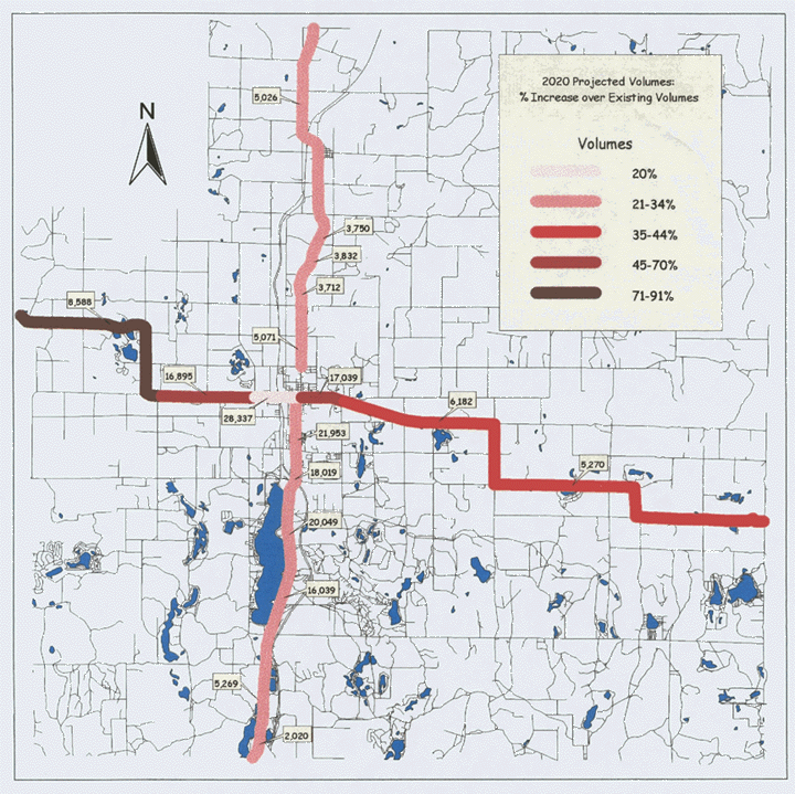
Projected 2020 traffic volumes for the M-32 and Old-27 corridors were compiled from a traffic model created by MDOT and from established counts taken by Wade-Trim, Inc. Traffic models are created based on existing and projected variables such as population, households, retail employment, and non-retail employment within a given area. These variables are organized into major traffic zone areas configured according to the local road layout. These models enable roadway volumes to be projected and displayed on any given roadway segment within the model boundaries. The projected annual average daily traffic (AADT) volumes are displayed in Figure 5.8 , and projected percent increase are displayed in Figure 5.9.
Operating Conditions
The majority of the corridor will continue to operate with sufficient reserve capacity. The corridor should continue to operate at a reasonably safe level. A cooperative, ongoing program between MDOT and local jurisdictions should be implemented to identify problem areas, monitor accident levels, monitor traffic volumes each year and monitor access development.
The study area west of the City of Gaylord on M-32 will see the highest projected increase in traffic, as shown in Figure 5.9. Old-27 is projected to see only a modest increase in future traffic volumes over existing volumes, ranging from 21-34%, while existing volumes along M-32 to the west of the City of Gaylord could be expected to rise as much as 71% to 91%.
Projected volumes within the urban areas surrounding the city of Gaylord, are mixed. Some areas can expect to see only small increases, such as in existing commercial locations. Other urban locations can be expected to see a higher increase in traffic, especially as the urban to rural boundary navigates to the east and west along M-32.
The Gaylord area will most likely have some operating deficiencies. The scope of this corridor study does not allow for site specific recommendations for these locations. This would require a specific study of the operational characteristics of each intersection. Consideration should be given to improving the existing infrastructure where the traffic is expected to increase the most; especially along land use that is zoned for future commercial use. Improvements such as the ones suggested in the existing operating conditions section and in Chapter 6, Access Management could be implemented. To eliminate the potential for an increase in traffic crashes at the locations of existing high crashes, right turn lanes can be used to reduce rear end collisions. Rear-end collisions are the main type of crashes occurring at these intersections.
Figure 5.8
Projected Daily Traffic Volumes
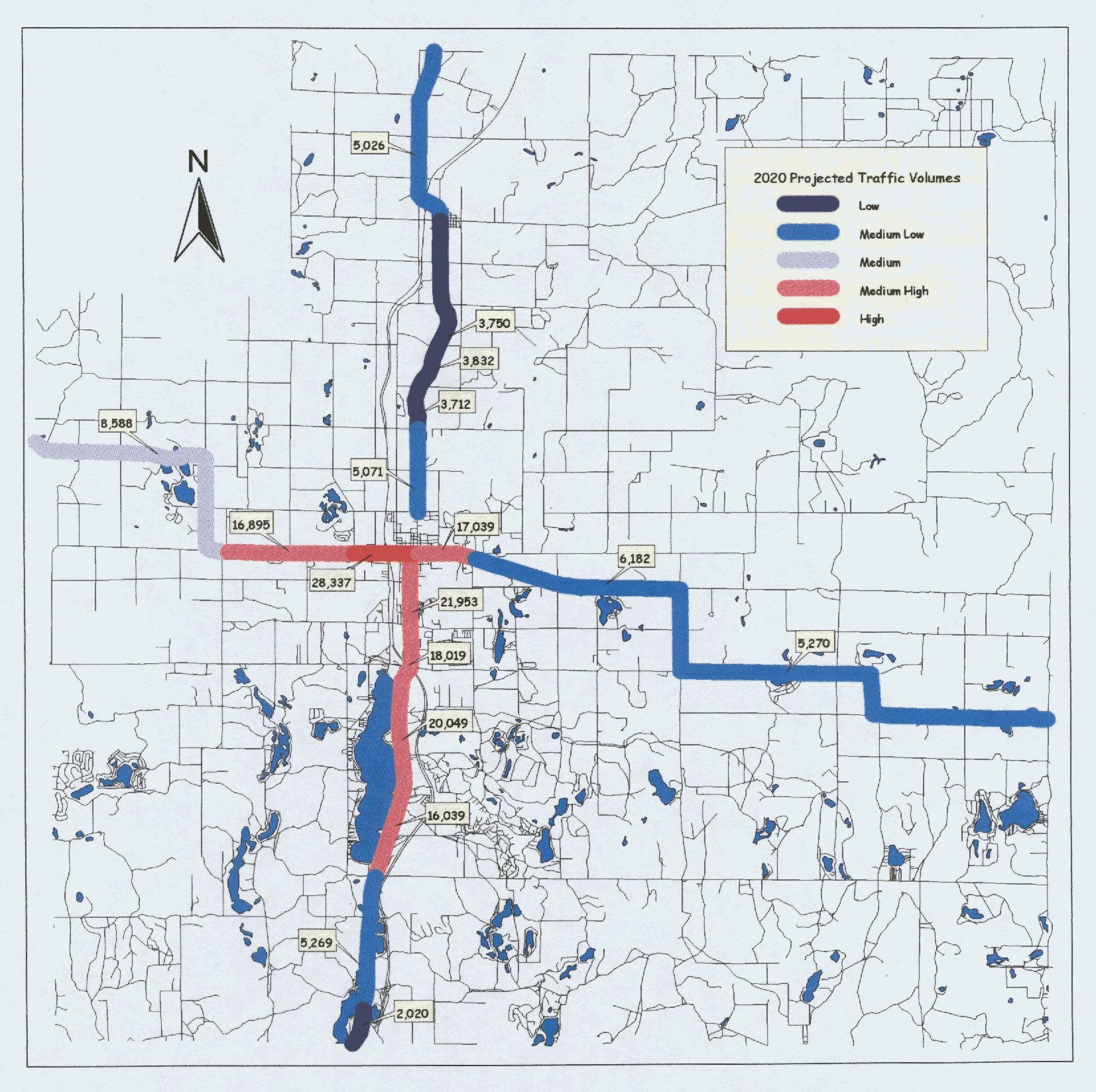
Figure 5.9
Projected Increase in Traffic Volumes