Status Of Planning And Zoning
Introduction
Zoning is the primary tool that local communities have to manage growth and development. Through local zoning, communities are able to preserve and enhance the character, property values and economic viability of the M-32 and Old 27/I-75 Business Loop corridors. In addition, zoning regulations are key to protecting both recent and proposed investments in the highway and utility infrastructure by maintaining traffic, capacity, speed and safety through access management zoning regulations.
The purpose of this chapter is to present the status of planning and zoning along the M-32 and Old 27/I-75 Business Loop study corridor. Furthermore, the presence of key corridor zoning regulations such as signs and access management in each community will be documented. It is not the intention to compare the strengths and weaknesses of zoning regulations among the various zoning ordinances. However, as a first step toward having consistent corridor zoning coverage along the entire length of the study area, model zoning ordinance regulations have been developed as part of this study.
Community Planning
Table 4.1 presents the status of planning along the corridor. Gaylord updated the City of Gaylord Master Plan in March of 1996. The Village of Vanderbilt General Plan was adopted in 1971. After nearly three decades of use, the plan is in the process of being updated and should be completed in 2000. Of all the townships along the study corridor, only Livingston Township has prepared a planning document. The Livingston Township Comprehensive Plan was adopted in August of 1991, and a Community Growth Management Study and Citizen Forum was prepared in September of 1996.
Otsego County plans for the remainder of the County and updated the Otsego County Comprehensive Plan in February of 1997.
Future Land Use Plans
Otsego County and Gaylord have completed master plan updates within the last six years. The Village of Vanderbilt is in the process of updating their master plan. Several townships have active planning programs, for example Livingston Township developed a master plan and completed a growth management forum in the mid 90's and Bagley Township has recently completed a DDA plan.
These community master plans present a desired future land use for the study area. The future land use is a vision of how the community wants to develop over the planning horizon, usually 20 years. Future land use plans typically consist of a map which displays future land use areas and accompanying text describing compatible uses in each land use area. An analysis of proposed types and intensities of future land uses within the corridor areas will provide a perspective into the potential changes, both in development and traffic conditions. For the purposes of this study, the future land use from the Otsego County and Gaylord master plans was encoded into NEMCOG's GIS/computer mapping system. Note, proposed future land use in the Bagley DDA plan will be discussed in the DDA section. (See Table 4.1)
|
Table 4.1 |
|||
|
Political Unit |
Land Use Plan Date Adopted |
Zoning Ordinance Date Adopted |
Other Related Planning Documents or General Law Ordinances |
|
Otsego County |
First land use plan prepared in 1939; updated in 1966 and 1981; current Comprehensive Plan adopted February 1997 |
Original Zoning Ordinance adopted in 1975; updated in 1993 and 1996; In the process of being updated; expected completion 2000 |
|
|
City of Gaylord |
First land use plan prepared in 1966; current Master Plan adopted March 1996 |
Updated in 1985; several amendments since 1985; in the process of being updated; expected completion 2000 |
Dangerous Buildings; Adult Businesses; Signs; DDA; Dangerous Buildings; Property Maintenance |
|
Village of Vanderbilt |
General Plan prepared in 1971; in the process of being updated; expected completion 2000 |
Original Zoning Ordinance adopted September 1972; minor amendments since 1972; in the process of being updated; expected completion 2000 |
Nuisance; Dangerous Structures; Supplemental Traffic |
|
Livingston Township |
Comprehensive Plan prepared in 1977; updated August 1991; amended October 1993 |
Otsego County Zoning |
Growth Management Plan prepared September 1996 |
|
Bagley Township |
None |
Otsego County Zoning |
DDA Plan prepared March 2000 |
Otsego County
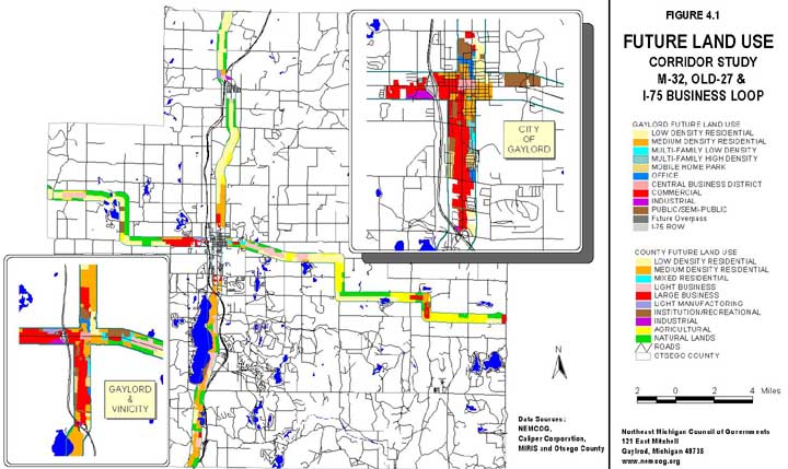
The Otsego County Master plan, adopted February, 1997, presents 10 future land use categories. Table 4.2 is a listing and description of these categories. Otsego County Zoning Department provided the future land use map in digital format. This digital map was imported into ArcView GIS format and "trimmed" to the corridor study area. Figure 4.1 is a display of the County's future land use map.
The future land use category that covers the largest area within the study corridor is Low Density Residential. This category recommends a density of one unit per two to five acres. The next largest category is Natural Lands, which recommends a dwelling unit density of one unit per five to ten acres. The third largest category is Agricultural, which recommends a density of one unit per two to five acres. Future land use areas recommending residential uses, including Agricultural and Natural Lands account for over 80 percent of the corridor study area under County jurisdiction.
Figure 4.1
Future Land Use
|
Table 4.2 Otsego County Future Land Use Categories |
|
|
Categories |
Descriptions |
|
Low Density Residential |
Low Density Residential is designed to accommodate single family dwellings at a density of one unit per two to five acres. The large residential lots provide privacy from neighbors and/or other development. This development is located on roads with light vehicular traffic. No municipal water or sewer service will be available. |
|
Medium Density Residential |
The Medium Density Residential designation is intended to incorporate existing subdivided areas and residential areas. This residential development area is designed to accommodate single family dwellings on lot sizes ranging between 20,000 sq. ft. and 88,000 sq. ft. |
|
Mixed Residential |
The Mixed Residential future land use category is intended to direct future residential growth to areas of the county where high value municipal services and infrastructure, such as paved roads, central water and sewer services are available. Satellite systems (water and sewer) may be required for development. Residential development designed to accommodate dwellings at a density of one unit per 20,000 sq. ft. or less. Higher density residential uses, such as apartments, townhouses, condominiums, small scale offices or manufactured home developments would be allowed. |
|
Light Business |
Light Business contains land used or planned for small retail or service establishments without large parking demands or heavy amounts or ingress and egress traffic. These areas would be compatible with adjacent mixed residential areas and provide services to residents such as convenience stores, personal services and similar services. The lot size would be determined by the site plan review process. |
|
Large Business or Business District |
This category anticipates large retail service establishments with large parking lots or a cluster of smaller retail and service businesses that are located along a major thoroughfare. These uses generate heavy vehicular traffic. This type of development needs municipal water and sewer, or may need a satellite water or sewer system. Recommended uses are: retail stores, shopping centers, business and personal services, professional offices, food service, lodging facilities, and similar uses. |
|
Light Manufacturing |
The Light Manufacturing future land use category is designed to provide sites for light manufacturing and wholesale storage and as distribution areas to retail stores or industrial uses. Since these facilities require lesser amounts of ingress and egress of traffic, sites do not have to abut or be adjacent to a primary county or secondary roads. |
|
Industrial |
Industrial future land use areas include existing manufacturing facilities, airports and extractive operations and areas to accommodate new industrial growth. The industrial future land use category is designed to provide sites for wholesale activities, warehouses, major repair operations, manufacturing and other industrial operations. These facilities can generate high traffic volumes during shift changes, require heavy use of infrastructure and municipal services, generate heavy truck traffic and require use of rail sidings. |
|
Institutional/ Recreational |
The Institutional category includes education, government, religious, health, correctional and military facilities. All buildings, grounds and parking lots associated with the facility are included within the institutional land use category. The Recreational category includes outdoor recreational facilities, parks and cemeteries. Included in this category are incidental buildings such as concessions stands, maintenance buildings, shelters, and restrooms. |
|
Agricultural |
This category includes land used or appropriate for use for farming, livestock and related activities. Farm dwellings and agricultural accessory buildings are compatible. These areas could serve as potential sending zones for development rights. This land use category could be compatible with low density residential (two to five acre lot sizes) or clustered housing with committed open space. |
|
Natural Lands |
Natural Lands is the most extensive land use category recommended for the county. Both private and public lands are located in this category. Primary uses to be encouraged include open space recreation such as golfing, skiing, hiking, hunting, fishing and camping; forestry and low impact agricultural. Very low density residential development (one house for every five or ten acres) would be allowed. |
|
Source: Otsego County Master Plan |
|
Commercial future land use categories cover 2165 acres of the corridor in the County and industrial/manufacturing accounts for 185 acres. The County's future land use plan supports the continuation and expansion of commercial nodes and commercial strip development along the corridor. A number of these areas are located along roads where the speed limits are 50 to 55 miles per hour. Below is a summary of the County's future land use within the Corridor:
Otsego County Future Land Uses within Study Corridor
Agricultural: 2,349.5 acres
Industrial: 27.9 acres
Institution/Recreation: 451.2 acres
Large Business: 805.0 acres
Light Business: 1,360.4 acres
Light Manufacturing: 157.0 acres
Low Density Residential: 4,311.7 acres
Medium Density Residential: 2,015.4 acres
Mixed Residential: 57.2 acres
Natural Lands: 3,233.2 acres
City of Gaylord
Gaylord's master plan was adopted March 6, 1996. The plan identifies 11 future land use categories. Table 4.3 is a summary of these categories. The City's future land use map was digitized, placed into ArcView format and "trimmed" to the corridor study area. Figure 4.1 is a display of the City's future land use map.
City's area inside the corridor study area: 1483.6 acres
Summary of the City's future land use (inside the study area):
Central Business District: 39.3 ac.
Commercial: 578.3 ac.
I-75 right-of-way: 37.5 ac.
Industrial: 44.2 ac.
Low Density Residential: 131.1 ac.
Medium Density Residential: 187.1 ac.
Multi-Family High Density: 30.7 ac.
Multi-Family Low Density: 13.7 ac.
Mobile Home Park: 69.3 ac.
Office: 46.1 ac.
Public/Semi-Public 306.3 ac.
The future land use category that covers the largest area within the study corridor is commercial with 578 acres. The total land are recommended for commercial and office uses is
664 acres. Medium Density Residential accounts for the largest residential future land use area. The total land area recommended for residential land uses is 432 acres within the study area. Over 90m percent of the land that fronts M-32, North Center Avenue and South Otsego Avenue is recommended for commercial and office uses.
Zoning
All of the townships in the study area rely on the zoning ordinance administered by Otsego County. Both the City of Gaylord and the Village of Vanderbilt have local zoning regulations. Table 4.1 shows the adoption date of zoning ordinances for each respective community. Another aspect of this study is to document the presence of key corridor zoning regulations in each zoning ordinance. Table 4.4 summarizes this information.
|
Table 4.3 City of Gaylord Future Land Use Categories |
|
|
Categories |
Descriptions |
|
Low Density Residential |
This category is devoted to single family dwellings with a minimum lot size of 12,000 square feet and width of 90 feet. These lots could be served by public water and sanitary sewer. Other uses such as churches, schools, and parks would be allowed as Special Use Permits. |
|
Medium Density Residential |
This land use category includes much of the existing single family residential areas within the City which is zoned R-2. A minimum lot size of 8,500 square feet with 60 feet of width is recommended for these areas which would be served by public water and sanitary sewer. Two family dwellings would be allowed in these areas but only by special use permits. |
|
Multi-Family Low Density Residential |
This future land use category includes multi-family or apartment development at a maximum density of eight units per acre. Up to 16 units per building could be allowed with planning approval. |
|
Multi-Family High Density Residential |
This category allows for multi-family dwellings (apartments) as well as two family dwellings up to a maximum density of 15 units per acre. |
|
Mobile Home Park |
This area allows for development of mobile home parks. |
|
Office |
This category encourages the preservation of existing single family houses on North Center Street between Mitchell and North Streets. Uses for this district would include professional and medical offices; studios for dance, art, or music; barber and beauty shops; flower shops; card and gift shops; art and craft stores; and tailor shops. |
|
Central Business District |
This category includes those existing uses within the downtown area of Gaylord. |
|
Commercial |
This area includes properties zoned C1 and C2. The plan recognizes the extension of commercial uses west on M-32 and north on Old 27 outside the City Limits. |
|
Industrial |
This category includes existing industrial land use areas in the City. The plan recommends future industrial development occur in those areas where utilities exist or are planned for and which have access to major streets. |
|
Light Manufacturing |
This category recognizes the dual need for providing opportunities for clean industrial uses in the Gaylord area and the need to protect the City's groundwater . Uses permitted within this category would include would include wholesale storage and distribution facilities, truck terminals, storage yards, machine shops, forest industries, essential public facilities and limited retail. |
|
Public Semi-Public |
This category refers to land devoted to governmental, institutional or similar activities generally deemed to be in the public interest such as public buildings, schools, cemeteries, and utility right-of-ways. |
|
Source: City of Gaylord Master Plan, March 6, 1996 |
|
Sign Regulations: Otsego County regulates the types and sizes of signs and billboards allowed in each zoning district under the County Zoning Ordinance. The City of Gaylord regulates signs and off-premises sign (billboards) for each zoning district under the Gaylord Sign Ordinance. Recommended amendments to the Village of Vanderbilt Zoning Ordinance include sign regulations for sizes and types allowed in each zoning district.
Adult Entertainment Regulations: Otsego County Zoning Ordinance allows adult entertainment businesses as a special permit use in the B-3 District. The City of Gaylord has an Adult Business Ordinance regulating such businesses. They are allowed in the C-2 Zoning District and must also be approved by special land use permit under the City’s Zoning Ordinance. Gaylord also regulates indecent exposure and pornographic or immoral activity under the City’s Disorderly Conduct Ordinance. The Village of Vanderbilt ordinances are silent on this subject.
Stormwater Regulations: The Otsego County Zoning Ordinance stipulates stormwater management requirements as part of the special use permit process. No specific stormwater management regulations were noted in any other ordinances reviewed. However, most include a broad statement in the site plan review regulations that stormwater should not run onto adjacent properties or impact surface water or wetlands.
|
Table 4.4 Summary of Land Use Regulations |
|||
|
Otsego County |
City of Gaylord |
Village of Vanderbilt |
|
|
Sign Regulations |
Regulations for size, type per zoning district in Zoning Ordinance; proposed amendment to add setback from R-O-W |
Sign Ordinance regulating size, type per zoning district |
Proposed amendment to add sign regulations for size limitations per zoning district to the Zoning Ordinance |
|
Adult Entertainment Regulations |
Allowed as special permit use in B-3 District under the Zoning Ordinance |
Adult Business Ordinance; allowed as special permit use in C-2 District under the Zoning Ordinance |
Not addressed |
|
Access Management Regulations |
Zoning Ordinance addresses site access alternatives, ingress/ egress spacing and driveway permits |
Included as part of site plan review under the Zoning Ordinance |
Not addressed |
|
Stormwater Management Regulations |
Included as part of special permit application under the Zoning Ordinance; Comprehensive Plan recommended developing Storm-water Management Ordinance |
Included as part of site plan review under the Zoning Ordinance |
Not addressed |
|
Aesthetics/Blight Regulations |
Landscaping, screening, buffering and restricted yard use regulations in the Zoning Ordinance |
Landscaping, screening and buffering regulations in the Zoning Ordinance; Dangerous Building Ordinance; Weeds and Grass Ordinance |
Proposed amendment to add landscape, screening and buffering regulations to the Zoning Ordinance; Nuisance Ordinance; Dangerous Structure Ordinance; Noxious Weed Ordinance |
Aesthetics and Blight Regulations: The Otsego County Zoning Ordinance contains requirements for landscape, buffering, screening and yard restrictions. Gaylord’s Zoning Ordinance includes landscape regulations, requiring screening of outdoor storage of materials, buffering between residential and other uses and landscaping off- street parking lots. Vanderbilt’s current Zoning Ordinance has no landscape regulations, but the on-going update process recommends landscape regulations to be included in the ordinance. Gaylord regulates blight through the Dangerous Buildings Ordinance and Weeds and Grass Ordinance. Vanderbilt regulates blight through the Nuisance Ordinance, Dangerous Structures Ordinance and Noxious Weeds Ordinance.
Access Management regulations: Otsego County has specific access management requirements in the Zoning Ordinance that addresses site access alternatives, ingress/egress spacing and driveway permits. Gaylord’s Zoning Ordinance contains certain aspects of access in the site plan review process. Most community ordinances contain broad statements such as the development should not increase traffic hazards or cause congestion on public highways.
Zoning Maps and Districts
Master plans, including the future land use plan, are implemented through zoning, capital improvement programs and recreation planning. Zoning is the primary tool used by most communities to implement their master plan. Zoning regulates the type, intensity and location of development in a community. Zoning maps for each community have been incorporated into ArcView GIS and trimmed to the study corridor. Additionally, information from each communities' zoning ordinance such as zoning districts, permitted uses, minimum lot sizes, minimum lot width and front set back will be presented. Figure 4.2 shows the current zoning for the City of Gaylord.
City of Gaylord
The City of Gaylord administers it's own zoning ordinance. The City is in the process of updating its zoning ordinance. The current ordinance establishes six zoning districts.
R-1 Single Family Residence District permits single family dwellings as well as nonresidential uses such as schools, parks, churches, country clubs, licensed residential care facility, and home occupations.
Location: Within the study corridor an area located north of East Huron and East Main Street and east of North. Elm is zoned for single family residential.
Minimum lot area: 8,500 sq. ft.
Minimum front set back: 25 ft.
Minimum lot width: 60 ft.
R-2 Multiple Residence District provides for mixed residential uses, including two-family and multiple family dwellings and single family dwellings. In addition to uses permitted in R-1, other uses for example, apartments, hospitals, nursing homes, private clubs, and in home physician, surgeon or dentist offices are permitted.
Location: The R-2 District accounts for the largest area zoned residential within the study area in the City of Gaylord.
Minimum lot area: Single Family and Two Family - 8,500 sq. ft., Multiple Dwellings - 2,900 sq. ft. per family.
Minimum front set back: 25 ft.
Minimum lot width: 60 ft.
B-1 Central Business District or downtown business district is the heart of Gaylord and allows for a mix of residential and nonresidential uses. Uses allowed in R-2 as well as apartments above businesses provide residential uses. A wide variety of commercial, retail, service, and office uses are permitted in the B-1 District.
Location: B-1 is located north of First Street, south of Mitchell Street, east of Detroit and Mackinac Railroad, and west of Elm Street.
Figure 4.2
Zoning Map
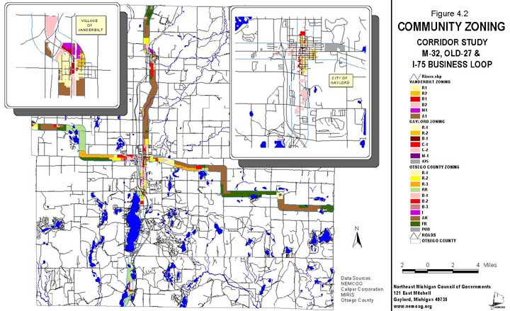
Minimum lot area: NA
Minimum front set back: NA.
Minimum lot width: NA
C-1 General Commercial District is intended to provide locations for commercial, service and retail establishments for local and passer-by-traffic. This district also allows uses permitted in R-2 Multiple Residence District.
Location: This district is located either side of South Otsego Avenue from 2nd Street to Grandview Boulevard, and either side of North Center Avenue from Petoskey Street to south of Fariview Street.
Minimum lot area: Same as R-2
Minimum front set back: 25 ft.
Minimum lot width: NA
C-2 Central Commercial permits uses allowed in C-1 and R-2 zoning districts, as well as certain light manufacturing and wholesale establishments. This zoning district accounts for nearly one half of the corridor study area within the City of Gaylord.
Location: The C-2 District is located either side of South Otsego Avenue from Grandview Boulevard to the city limits, and west of the downtown to the city limits. A number of the blocks surrounding the Central Business District are zoned C-2.
Minimum lot area: Same as R-2
Minimum front set back: Same as R-2 if building is used for both residential and commercial
Minimum lot width: NA
M-1 Manufacturing District provides locations for manufacturing and light industry.
Location: A small area west of Dickerson Road and South of Barnyard Boulevard within the corridor is zoned M-1
Minimum lot area: NA
Minimum front set back: Same as C-1
Minimum lot width: NA
Village of Vanderbilt
In October of 1972, Vanderbilt adopted a zoning ordinance and has been administering the ordinance since that time. The Village is in the process of amending its zoning ordinance and it is anticipated the amendment process will be completed in 2000. The information below reflects proposed ordinance amendments. There are eight zoning districts in Vanderbilt's ordinance, six of which are located in the study corridor. Information on the six districts will be presented. Figure 4.2 depicts the current districts for the Village of Vanderbilt.
A-1 Agricultural District is established to conserve areas for agricultural use. Uses are limited to farming operations, single family residential, commercial and public recreation and public buildings.
Location: The southern part of the corridor as well as properties west of I-75 fall within the Agricultural Zoning District.
Minimum lot area: 10 acres
Minimum front set back: 25 ft.
Minimum lot width: 500 ft.
R-1 Single Family / Two Family Residential District is intended to provide for a diverse residential environment. The district permits single and two family dwellings, schools, public parks and churches.
Location: The R-1 district borders the central down business district on three sides.
Minimum lot area: 12,000 sq. ft.
Minimum front set back: 25 ft.
Minimum lot width: 80 ft.
R-2 Multiple Family District is developed to accommodate a mixture of housing types, including single family structures, mobile homes and multiple family structures such as apartments and townhouses.
Location: The R-2 district is located on the northeast side of the downtown area.
Minimum lot area: 12,000 sq. ft.
Minimum front set back: 25 ft.
Minimum lot width: 80 ft.
B-1 Local Business District is designed to meet neighborhood retail and services needs. Permitted uses include retail, office, restaurants, personal services, banking, medical, private clubs and existing dwellings. Special condition uses are allowed.
Location: Local Business District includes the downtown area and properties along the north side of Old 27 and east of the I-75 interchange.
Minimum lot area: 3,200 sq. ft.
Minimum front set back: 25 ft. on lots adjacent to residential districts
Minimum lot width: 25 ft.
B-2 Highway Service District is automobile oriented and is intended to accommodate retail and service activity of passer-by-traffic. Permitted uses include all those allowed for in B-1, in addition to auto sales, motels, casinos and gaming facilities, indoor commercial recreation, tourists facilities, and theatres. Special condition uses include outdoor sales, Lumber yards, outdoor commercial recreation, warehouses, and campgrounds.
Location: Properties zoned B-2 border the southern approach to the Village along Old 27 and border the southeast side and northwest side of the I-75 intersection.
Minimum lot area: 8,500 sq. ft.
Minimum front set back: 25 ft.
Minimum lot width: 80 ft.
M-1 Industrial District is intended to provide locations for industrial, wholesale and storage facilities.
Location: The M-1 district is located in the northern part of the Village and falls within the study corridor.
Minimum lot area: 2 acres
Minimum front set back: 40 ft.
Minimum lot width: 200 ft.
Otsego County
Otsego County's zoning ordinance was last amended in April 17, 1997. A majority of the study corridor falls under the County's jurisdiction. The current ordinance establishes ten zoning districts to regulate land uses within the county. Figure 4.2 is a zoning map of the County within the study corridor.
R1 - Residential District provides for one and two family (duplex) dwelling sites in addition to residential related uses subject to special conditions.
Location: Residential zoning is located on M-32 on the east edge of Elmira; east and west edge of Gaylord and in Johannesburg. On Old 27 north, there are small areas at the northern edge of Gaylord and the south edge of Vanderbilt.
Minimum lot area: 20,000 sq. ft.
Minimum front set back: 25 ft.
Minimum lot width: 100 ft.
R2 - General Residential District provides for multiple family structures and is intended to serve as a transitional use zone between residential districts and nonresidential districts. In addition to single and multiple family residential uses, retail specialty stores are principal permitted uses provided there is direct access to county primary roads and state trunklines. Under special conditions a variety of nonresidential uses are permitted and include: motels, hotels, clubs, professional offices, and convenience stores, provided there is access to county primary roads and state trunklines.
Location: Areas zoned for R2 are located at the east edge of Elmira, and east and west of Gaylord on M-32. General residential zones are located north of Gaylord and Vanderbilt. R2 zoned areas within the corridor are located in Bagley and Otsego Lake Township, particularly, along the east side of Old 27 south.
Minimum lot area: 20,000 sq. ft.
Minimum front set back: 25 ft.
Minimum lot width: 100 ft.
R3 - Residential Estate District provides for rural residential development on lots 10 acres and larger. Principal uses permitted are single family and duplex structures, along with non residential uses such as fraternal lodges, day nursery schools, home business, and specialty retail shops. This district also allows for a wide variety of uses subject to special conditions. Uses include all permitted uses subject to special conditions in R1 and R2 districts plus other nonresidential uses such as gasoline stations with store, travel trailer courts, commercial campgrounds and manufactured housing parks.
Location: Areas zoned R3 are located along the south side of M-32 between Krys and Big Lake Roads and on the north side of M-32 between Grandview Drive and South Townline Roads. There is another small area within the corridor between Vanderbilt and Gaylord on Old 27 north.
Minimum lot area: 40,000 sq. ft.
Minimum front set back: 25 ft.
Minimum lot width: 100 ft.
RR - Recreation Residential is designed to accommodate cottage and vacation home developments. The intention is to discourage the mixing of residential and nonresidential uses. One family dwellings, public parks, existing farms, home businesses and Bed & Breakfast/tourist home are some of the principal uses. Some of the permitted uses subject to
special conditions are community boat launching ramps, private noncommercial parks, golf courses, marinas, restaurants, and recreation camps.
Location: Areas zoned Recreation Residential within the Corridor are associated with lakes. These areas are located near Lake Twenty-seven west of Gaylord and Swede, Johannesburg, Lewis, and Big Lakes east of Gaylord. In Bagley and Otsego Lake Township lands between Old 27 and Otsego Lake, and segments of the corridor adjacent to Heart, Little Bradford and Big Bradford Lakes are all zoned RR.
Minimum lot area: 20,000 sq. ft.
Minimum front set back: 25 ft.
Minimum lot width: 100 ft.
B1 - Local Business District provides for neighborhood shopping areas, personal services and professional offices that are compatible with and of service to residential uses. Under uses subject to special conditions, higher traffic generators that draw people from outside the local neighborhood, motels, hotels, gas stations, sales and rental of recreation vehicles, autos, manufactured homes, shopping centers and shopping malls.
Location: Small areas zoned for B1 are located outside of Gaylord on M-32 and Old 27 north; and at the intersections of M-32 and Camp Ten Road, and Old 27 north and Thumb Lake Road.
Minimum lot area: 10,000 sq. ft.
Minimum front set back: 30 ft.
Minimum lot width: 100 ft.
B2 - General Business District allows for diversified business types to serve passer-by-traffic. These types of developments serve area wide customers and tend to be high traffic generators.
Location: Commercial nodes are located along M-32 and Old 27. Sites outside the greater Gaylord area are located on roads where the speed limits are 55 mph.
Minimum lot area: 10,000 sq. ft.
Minimum front set back: 30 ft.
Minimum lot width: 100 ft.
B3 - Business, Light Manufacturing is designed to provide sites for light manufacturing, and wholesale storage and as a distribution center to retail and industrial uses. These uses must have access to county primary and secondary roads without passing through residential districts.
Location: B3 zoning districts in the corridor are located outside of Gaylord on the north, south and west sides, north of Vanderbilt, and in the communities of Waters and Elmira.
Minimum lot area: 20,000 sq. ft.
Minimum front set back: 30 ft.
Minimum lot width: 100 ft.
I - Industrial District is designed to accommodate wholesale activities, warehouses, major repair operations, manufacturing and other industrial operations.
Location: There are two small areas of industrial zoning within the study area, on the northern edge of Vanderbilt and on the southern edge of Gaylord.
Minimum lot area: 40,000 sq. ft.
Minimum front set back: 30 ft.
Minimum lot width: 150 ft.
FR - Forestry Recreation District is intended to retain the rural areas for resource purposes, while recognizing the need to allow multiple uses considered acceptable in a rural environment. Along with one family and duplex dwellings, a number of resource and nonresidential uses are permitted. These include farms, tree farms, tree nurseries, public parks, bed & breakfasts/tourist homes, and commercial residential facilities. Uses subject to special conditions range from sportsman clubs, game preserves and private non-commercial recreation facilities to restaurants, solid waste transfer facilities and forest industries such as permanent sawmills, planing mills and veneer mills.
Location: Lands zoned Forestry Recreation are located within all legs of the corridor study area, with the greatest amounts along M-32.
Minimum lot area: 88,000 sq. ft.
Minimum front set back: 50 ft.
Minimum lot width: 150 ft.
AR - Agricultural Resource District is intended to encourage the maintenance of productive farm and agricultural land for growing, raising, or production of food stuffs. Single family dwellings are permitted. Two family dwellings as well a two detached single family dwellings are permitted provided minimum lot width is 300 feet. Additionally, the two detached single family dwellings must be on lots of ten acres in size. A number of resource related uses are permitted along with non-farm uses such as bed & breakfasts, commercial residential care facilities and veterinary clinics. Uses subject to special conditions include resource based commercial and industrial uses. Non-resource related uses range from gasoline stations with stores, institutions (detention facilities), shopping centers, shopping malls, restaurants, solid waster transfer facilities, surface mining, and campgrounds.
Location: Segments of the corridor zoned Agricultural Resources are located east of Elmira, with extensive areas on Old 27 north and M-32 east.
Minimum lot area: 88,000 sq. ft. (two detached single family - 10 acres)
Minimum front set back: 50 ft.
Minimum lot width: 150 ft. (duplex or two detached single family dwellings- 300 ft.)
Model Ordinances
This study provides model zoning ordinance regulations for signs/billboards, aesthetics/blight, adult entertainment, stormwater management, and access management. It is recognized that certain M-32 and Old 27/I-75 Business Loop communities may already have effective regulations in place for certain aspects. But the M-32 and Old 27/I-75 Business Loop ordinance recommendations and models are intended to establish a consistent regulatory framework across the entire corridor. Therefore, Appendix A contains an example of a model ordinance in each category of concern. It should be noted that these model regulations would need slight modifications to properly fit into each separate community’s zoning ordinance.