Access Management
Introduction
Access management provides a systematic approach to balancing the access and mobility necessities of a roadway. Access management can be defined as the process of managing access to land development, while simultaneously preserving the flow of traffic on the surrounding public road system.
Property owners have a right to reasonable access to the general system of streets and highways. In conjunction, adjacent roadway users have the right to freedom of movement, safety, and efficient expenditure of public funds. Balancing these interests is critical at locations where significant changes to the transportation system and/or surrounding land uses are occurring. The safe and efficient operation of the transportation system calls for effectively managing highway access, via driveways, streets, or other access points.
The specific techniques for managing access involve the application of established traffic engineering and planning principles. Ideally, these principles will:
The application of these principles will minimize disruptions to through traffic caused by access drives and intersections. More specifically, good access management can:
Driveway Spacing
Access management increases the spacing between driveways, thus reducing the number and variety of events to which drivers along the corridor must respond. Close spacing between unsignalized driveways forces the driver to watch for ingress and egress traffic at several locations simultaneously. Increased spacing translates into fewer accidents, savings in travel time, and preservation of corridor capacity.
Driveways should be located to limit interference with the free movement of roadway traffic, and to provide the most favorable sight distance and driveway grade. No direct access drive should be located in the operational area of a signalized intersection.
Driveway spacing and location standards are based upon several factors. These include characteristics such as site frontage, roadway width, roadway classification, driver sight distance, and (most importantly) roadway speed. The following is a discussion of various factors that dictate driveway spacing and location.
Roadway Speed
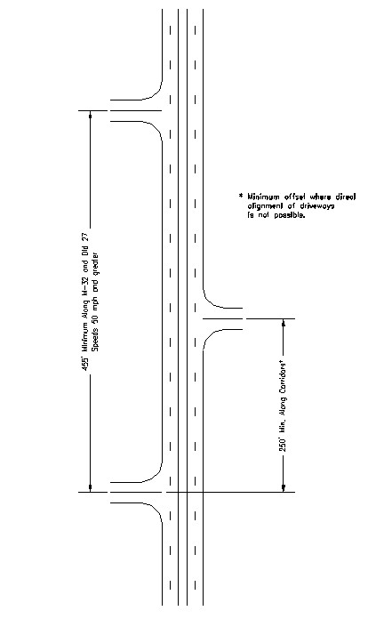
The prevailing speed on the roadway is a primary factor in determining proper driveway spacing. Naturally, the higher the speed of the roadway, the more driveway spacing that is required. Local driveway spacing standards can be derived from a variety of national references. Table 6.1 displays desirable separation distances for access drives and Figure 6.1 displays the recommended driveway spacing for the rural areas where the speed limit is 55 mph.
|
Table 6.1 Desirable Separation of Adjacent Driveways |
|
|
Highway Speed |
Minimum Driveway Spacing |
|
25 mph |
135 feet |
|
30 mph |
185 feet |
|
35 mph |
245 feet |
|
40 mph |
300 feet |
|
45 mph |
350 feet |
|
50 mph & above |
455 feet |
Figure 6.1
Minimum Offset
All site plans for proposed developments should show the location of all proposed and existing driveways within the area of the proposed development. The location of all of the proposed driveways should be reviewed to determine if proper driveway spacing will be maintained.
Sight Distance
Access drives should be placed at locations that provide adequate intersection and stopping sight distance. These locations often occur at the top or bottom of inclines. In hilly areas, proper locations can be at a premium, and shared access might be necessary. Often, the best locations for sight distance may create unfavorable driveway grades on the site. Much of M-32 and Old 27 travel over a somewhat rolling stretch of land, so sight distance is an issue in these areas along this corridor. Another potential issue might involve the trimming of brush or vegetation near intersections, within the highway right-of-way, so that approaching motorists have an adequate view of other approaching vehicles.
The required stopping sight distance for wet pavement is listed in the AASHTO manual Geometric Design of Highways and Streets, 1994 edition:
Design Speed (converted from km/h to mph) |
Stopping Sight Distance for Design (feet) |
24.9 mph |
145.7 feet |
|
31.1 mph |
188.3 - 206.0 feet |
|
37.3 mph |
243.8 - 277.6 feet |
|
43.5 mph |
308.7 - 363.5 feet |
|
49.7 mph |
370.1 - 457.3 feet |
|
55.9 mph |
430.4 - 553.5 feet |
|
68.3 mph |
588.9 - 808.4 feet |
|
74.6 mph |
665.7 - 937.0 feet |
Location of Nearby Intersections
As previously stated, access driveways should not be placed in the area of operation of an adjacent intersection. Greater spacing may be required due to stacking requirements of the approaches to the intersection. This can be particularly evident around signalized intersections.
Achieving proper corner clearance involves regulating the distance between a crossroad intersection and the nearest driveway location. Corner clearance is defined as the distance, measured along the back of the arterial curb, from the nearest edge of an access drive to the nearest edge of the intersection.
Moving the basic driveway conflict area away from the vicinity of an intersection can be accomplished by regulating the distance from the driveway to the intersection. The major effect is that vehicles will be delayed less by standing queues at signalized intersections. A possible tradeoff is that access to some corner commercial properties may be partially or totally denied access.
Minimum driveway setbacks should be considered at individual intersections, and should be based on typical queue lengths that still allows sufficient movement to and from a driveway. In rural areas, minimum corner clearances of 300 feet on M-32 and Old 27 and 200 feet on the side roads should be maintained. In many instances, the minimum corner clearance will be governed by the clear vision corners.
In urban areas such as near the City of Gaylord, slightly shorter corner clearances are acceptable as speed limits decrease. The location of existing driveways and the amount of available roadway frontage that the property has will dictate this. Each proposed driveway will need to be reviewed on an individual basis.
Type and Size of Development
Location and spacing requirements are more critical for access driveways to large developments or high traffic generators such as Wal-Mart. These driveways often operate as major intersections themselves, with signalization sometimes present. Greater spacing must be provided to allow for left turn storage on the main roadway and to reduce conflict points.
Maximum Number of Access Drives Per Property Frontage
This general access control standard limits the number of driveways per property relative to the length of available frontage. Regulating the number of driveways permitted for a specific frontage could have a significant impact on the business activity at that location. This should be considered before denial for an additional driveway is given, or before an existing driveway is closed. The allowable number of access drives typically follows the recommendations outlined below:
Driveway Design
Establishing access drive design criteria is essential in improving traffic operations and safety. Design standards outline geometric requirements regarding driveway widths, corner radii, taper lengths, and passing lanes to name a few. Driveways directly accessing either corridor must follow MDOT’s driveway design standards listed in the, "Rules Regulating Driveways, Banners, and Parades, 1998." The following is a discussion of driveway design standards for typical access locations.
Commercial Driveways
Width - All commercial driveways should have a width sufficient for the particular land use and anticipated traffic flow with a minimum width of 16 feet for a one-way drive and 25 feet for a two-way drive. The maximum width should be 19 feet for a one-way drive and 36 feet for a two-way drive. As an exception, 39 feet may be allowed or required to provide for an entrance lane and two exit lanes. These widths should be measured at right angles to the centerline of the driveway at the right-of-way line.
Radii - All commercial driveways should have radii large enough to accommodate the largest vehicle that will normally use it without creating undue congestion or hazard on the through highway. The minimum entrance radius allowed should be 25 feet and the minimum exit radius allowed should be 20 feet.
Tapers, Deceleration Lanes, and Passing Lanes - When a commercial establishment will generate high traffic volumes, deceleration tapers may be required. Larger commercial establishments may require deceleration lanes and passing lanes opposite the driveway to facilitate the anticipated traffic flow. These design considerations are addressed in detail in ensuing sections.
Angled Driveways - When the property owner desires to construct dual commercial driveways at other than 90 degrees to the centerline of the road, the near driveway on the right side as approaching should not have less than a 45 degree angle with the centerline of the road and the far driveway should not have less than a 60 degree angle with the centerline of the road.
Profile - All commercial driveways should be built to a sidewalk elevation at the right-of-way line. Beyond the right-of-way line, the grade should not exceed 8 percent. Some examples of layouts for driveways are shown in Figures 6.2 and 6.3.
Private Street Entrances
A private street entrance is defined as any driveway serving two or more residential parcels.
Width - The minimum width allowed is 22 feet and the maximum width allowed is 30 feet.
Radii - The minimum entrance radius allowed is 20 feet. The minimum exit radius allowed is 15 feet.
Residential Driveways
A residential driveway is defined as any driveway serving the residents of a single or two-family dwelling, or a farmyard adjacent to a farm resident.
Width - All residential driveways should have a minimum width of 10 feet and a maximum width of 20 feet, measured at right angles to the centerline of the driveway at the right-of-way line.
Offset - To facilitate vehicle movements, the driveway approach should be offset from the near side of the driveway 8 feet and from the far side of the driveway 4 feet; measured at the pavement edge.
Profile - All residential driveways should be built to a sidewalk elevation at the right-of-way line.
Figure 6.2
Driveway Configurations
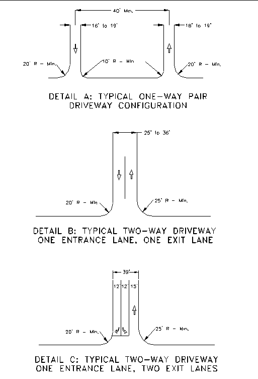
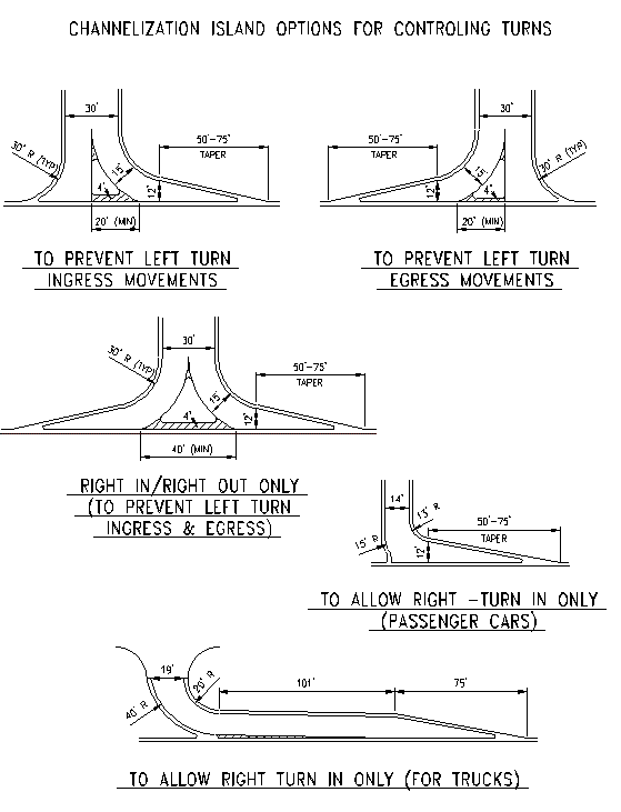
Figure 6.3
Channelization Island Options
Joint Driveways
When both property owners abutting a common property line agree, they may construct a joint commercial driveway that should meet these rules as if their frontages were under a single ownership. Joint driveways may be either commercial or residential, however, a commercial lot should not share a driveway with a residential lot. When consolidating residential driveways, consideration must be given to social issues such as maintenance and conflicts over usage. Driveway consolidation is addressed in detail later in the following section of this report.
Driveway Consolidation
Shared access drives are used to reduce the number of access points along a corridor while maintaining reasonable access to adjacent land uses. A shared access drive generally serves only two land uses that individually generate a relatively low number of trips.
As stated previously, a joint commercial driveway may be constructed if both property owners abutting a common property line agree. This general operating practice encourages adjacent property owners to construct shared driveways in lieu of separate driveways. Strategies for implementing this access control measure include closing existing driveways or authorizing joint-use driveways. The feasibility of this measure is viewed primarily at the permit-authorization stage. A shared access drive will result in a reduction in the concentration of driveways along a roadway, thus reducing the frequency and severity of conflicts.
The physical means by which access can be consolidated between two adjacent properties involves the construction of a joint-use driveway between the two properties. It is recommended that both property owners own the shared access drive. That is, the driveway should straddle the property line dividing the two establishments. The resulting joint-use parking area should be accompanied by an efficient internal circulation plan.
Service Roads
Service or frontage roads provide access and internal circulation to a number of developments. Service drives and frontage roads are useful because they provide a pathway to many sites while minimizing the number of access drives along the corridor. Service drives may be appropriate when a concentration of establishments exists. If locations exist where heavy traffic enters and exits various sites in a concentrated area, it is desirable to divert this traffic off of the main roadway so that the turning movements will occur off of the main roadway. The service drive may be configured such that development traffic can access the main roadway at a signalized intersection where movements can be controlled, or at a collector road (side street).
Service drives are usually constructed and maintained by the property owner or an association of adjacent owners. The service drive itself should be constructed to public roadway standards in regard to both cross section and materials design, as well as alignment. Since, by definition, these internal roadways would be serving several uses with numerous driveways, any additional use such as on-street parking should be prohibited. The alignment of service and frontage drives should be based on several factors including presence of existing buildings, location of property lines, existing wetlands constraints, and maximizing service drive operations. Some typical service road applications are shown in Figure 6-4.
Auxiliary Lanes
Right Turn Deceleration Taper
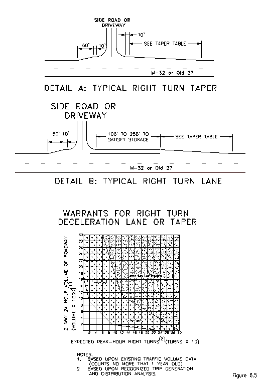
The following is a guideline for requiring the installation of a right turn deceleration taper along M-32 and Old 27 approaching an access drive. Deceleration tapers reduce the potential for rear end collisions by removing turning vehicles from the high speed through lanes. Deceleration tapers are recommended when the right turn volume into a driveway exceeds 300 vehicles per day. The length of these tapers is based on the travelling speed of the roadway. Table 6.2 displays desirable taper lengths as a function of roadway speed and Figure 6-5 displays the typical layout for the right turn lanes and deceleration tapers. Also included in Figure 6-5 is a Warrant Graph for determining the need for a right-turn lane or deceleration taper.
|
Table 6.2 Desirable Deceleration Taper Lengths |
|
|
Highway Speed |
Taper Length |
|
30 mph |
50 feet |
|
35 mph |
75 feet |
|
40 mph |
100 feet |
|
45 mph |
130 feet |
|
50 mph |
180 feet |
|
55 mph |
225 feet |
Right Turn Deceleration Lane
The following is a guideline for requiring the installation of a right turn deceleration lane. Deceleration lanes also reduce the potential for rear end collisions by removing turning vehicles from the high speed through lanes. Deceleration lanes are recommended when the right turn volume into a driveway exceeds 600 vehicles per day. The length of a deceleration lane can vary from 75 to 250 feet and is dependent on the amount of stacking required for vehicles entering the driveway. Deceleration lanes are often placed at signalized access points. Tapers of the appropriate length should be placed in advance of these lanes.
Figure 6.4
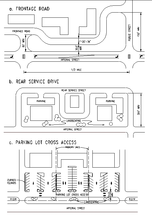
Figure 6.5
Two-Way Left Turn lane
The following is a guideline for requiring the installation of a two-way left turn lane. Center left- turn lanes are provided to remove left turning vehicles from through traffic lanes and store them in the median area until an acceptable gap appears. A center left turn lane completely shadows turning vehicles from both through traffic streams resulting in less accidents. Delay to through vehicular traffic would also be reduced since left turning vehicle queues would not block the through lanes.
A center left turn lane is warranted on multi-lane highways that have closely spaced driveways with a uniform and medium density of left turns along the highway. Highway volumes and speeds should exceed 10,000 vehicles per day and 30 miles per hour respectively. High accident rates involving left turn maneuvers also warrant a center left turn lane.
Additional Exit Lane for an Access Drive
The following is a guideline for determining whether an additional egress lane should be established for an access drive. Additional lanes allow right turn or left turn egress maneuvers to be made more efficiently because drivers are not delayed by egress vehicles wanting to turn in alternate directions. The egress capacity of the driveway is also significantly increased. Total driveway delay should decrease significantly because of the increased capacity due to the separation of egress turning traffic.
This technique is applicable for all highway types and at driveway locations where egress maneuvers are hindered because separate turning lanes are not provided. Highway speeds should normally exceed 30 miles per hour with highway volumes surpassing 5,000 vehicles per day. Existing driveway volumes should exceed 1,000 vehicles per day (approximately 500 egress trips).
Medians
One approach to managing access is to use medians of various designs to limit left-turn vehicle movements, channel traffic so that it flows more efficiently, and provide cross walk ‘safe havens’ for pedestrians and bicyclists. Landscaped green medians also provide for a more beautiful community and tend to ‘calm’ or slow the speed of through traffic.
Some cross-section examples of medians can be seen in Figure 6.6, from the AASHTO Geometric Design of Highways and Streets manual, 1994 edition. These types of medians are used to separate and channel traffic on arterial roadways. According to the manual:
reduced. Pedestrians crossing the divided arterial are required to watch traffic in only one direction at a time and are given a welcome respite at the median. Where the median is wide enough, crossing and left-turning vehicles can slow down or stop between the one-way pavements to take advantage of breaks in traffic and cross when it is safe to do so. Divided multilane arterials make for more relaxed and pleasant operation, particularly in inclement weather and at night when headlight glare is bothersome. Headlight glare is reduced somewhat by narrow medians but can almost be eliminated by wide medians.The principal advantages of dividing the multilane arterial are increased safety, comfort, and ease of operation. Of significance is the reduction in head-on collisions and virtual elimination of such accidents on sections with wide medians. These accidents usually are serious. Where medianlanes for left turns are provided, rear-end collisions and other inconven-iences to through traffic resulting from left-turn movements are greatly
The National Highway Institute (NHI), in Course No. 15255, reports that not only do the use of curbed medians and channelized intersections increase operational safety, but capacity of the roadway is also increased. The reason for this is that highway traffic flow is smoothed by having decreased traffic conflicts. Opposing lanes are separated, traffic is automatically regulated by physically prohibiting certain movements, motorists are more aware of the proper use of travel lanes and intersections, turning movements are positively controlled, and pedestrians are protected by a safe refuge area.
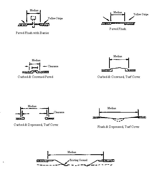
Figure 6.6, Typical Medians on Divided Arterials
Source: AASHTO, Geometric Design of Highways and Streets, 1994
The following two graphs (Figure 6.7) show the motorist and pedestrian safety benefits of retrofitting arterials that had a two-way left turn lane (TWLTL) with a raised median.
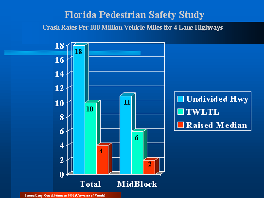
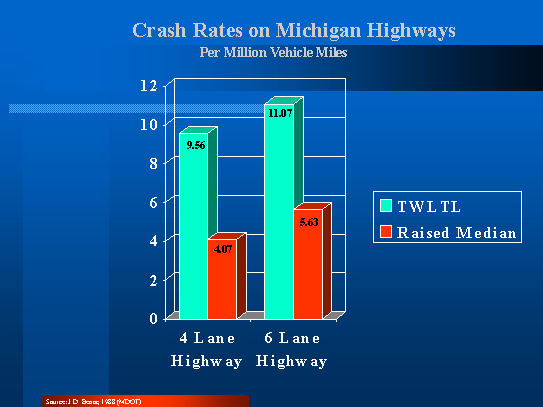
Figure 6.7, Safety Benefits of Medians
There is always some concern that good access management, while enhancing safety, can be a detriment to economic development. In fact, good access management techniques including the use of medians to channel traffic and limit left turning movements can be beneficial or at least not harmful to businesses located along the managed arterial roadway, according to a 1996 study by the Iowa Department of Transportation
(IDOT). The IDOT study compared business owners’ opinions on roadways in several municipalities on which access management improvements were made. In almost all cases before the changes were made, the business owners felt that limiting turning movements would harm their business. After the improvements were made, however, the vast majority (86%) felt that their business sales had either stayed the same (53%) or had increased (33%). Another
9% were uncertain, and 5% felt that their sales had been hurt by the improvements
(see Figure 6.8 ).
Locations of Case Studies
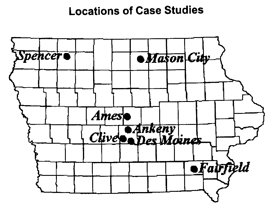
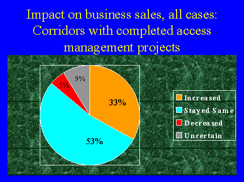
Figure 6.8, Business survey conducted in Iowa municipalities;
Source: Iowa Access Management Research & Awareness Project 1996, IDOT
Trees and Landscaping
According to Walkable Communities, Inc., motorists will drive a more safe and prudent speed on a roadway with tree plantings than on one without plantings, on an otherwise identically designed roadway. Speed limit signs make little difference, since motorists tend to drive at a speed that seems comfortable regardless of the posted speed limit. Trees and other landscaping gives motorists the impression that the roadway is narrower, and therefore it feels more comfortable to drive at a lower speed.
Closely planted trees along a roadway can also provide the motorist with a sense of speed when the trees appear to be going by very quickly, causing the motorist to drive a little slower. Interestingly, slower vehicles do not necessarily decrease the capacity of a roadway. This is because a smaller gap is possible between vehicles, allowing for a greater volume of traffic in any given segment. If tree plantings are used in combination with good access management designs, traffic will consist of a constant smooth flow of closely spaced vehicles. Studies show that this is a much safer condition than fast moving traffic that is forced to periodically stop and start again due to conflicts with merging and turning vehicles.
Traffic Signals
Offering a traffic signal is an effective way to entice property owners to consolidate and share driveways. However, caution should be taken when utilizing this approach. In general, traffic signals should only be placed at the section line roadways, when warranted, and at the half-mile points between section line roadways. This type of signal placement will promote traffic signal progression and preserve the through traffic capacity of the M-32 and Old 27 corridor. Traffic signals placed too closely together will decrease traffic signal progression and increase motorist delay. Consideration for traffic progression must always be taken into account when considering the placement of a new signal.
Thresholds for Requiring Traffic Impact Studies
The following discussion consists of pertinent excerpts from Evaluating Traffic Impact Studies: A Recommended Practice for Michigan Communities (McKenna Associates; 1994). This manual was sponsored by Tri-County Regional Planning, the Michigan Department of Transportation, and the Southeast Michigan Council of Governments, and is a widely used and accepted guide for requiring, conducting, and evaluating traffic impact studies.
Communities often are concerned with the traffic implications of land use decisions. In some cases, communities deny proposed development based on perceived traffic impacts without having a clear understanding of how to evaluate and mitigate traffic impacts. Conversely, some developments are established that result in unforeseen traffic consequences to the street system.
A traffic impact analysis is a specialized study that assesses the effects that a particular development will have on the surrounding transportation network. The lack of uniform requirements and procedures for traffic impact studies result in a number of problems, some of which include:
Some communities require traffic impact studies only after there is a problem.
Some communities require traffic impact studies for very small scale projects which have ultimately negligible impacts on the roadway.
Types of Traffic Impact Studies
Four basic types of traffic studies exist. They are described below.
Rezoning Traffic Study - A traffic study for a rezoning request is different than one for a specific use. A community needs to consider all of the uses that potentially could be developed under the requested zoning district, regardless of any specific use being proposed. A traffic study for rezoning should compare the potential trip generation of land uses allowed under the requested zoning, with those uses allowed under the permitted zoning. The community staff or the planning commission may want to identify three to four typical uses in both the current and requested zoning district.
Traffic Impact Assessment - This type of study is recommended for smaller scale projects which should not have a significant impact on the overall transportation system, but will have impacts at the site access points. The analysis for this type of study focuses on the proposed site driveways.
Traffic Impact Statement - This is the traditional traffic impact study that evaluates impacts at site access points as well as appropriate nearby intersections.
Regional Traffic Analysis - This type of study is recommended for very large regional developments such as large shopping malls and arenas. The study evaluates the impacts on the local streets and the regional transportation facilities such as freeways and major through arterials.
Trip Generation Thresholds
The trip generation of a proposed development is the number of inbound and outbound vehicle trips that are expected to be generated by a development throughout an average day or during a peak hour. The process of using trip generation thresholds is as follows:
Trip generation thresholds are commonly used as discussed below.
Thresholds for Rezoning Requests
Evaluating the traffic impacts of a proposed rezoning is difficult to determine since a rezoning usually permits any one of a number of uses. The following are recommended thresholds for requiring a rezoning traffic study.
Thresholds for Site Plans, Plats, Mobile Home Parks, and Condominium Projects
Traffic studies for site plans, plats, mobile home parks, and condominium projects should be more detailed than those for rezoning since the use and proposed site design are established. Thus, even if an initial traffic study was completed for a rezoning, a more detailed study would usually be required for the site plan. The following thresholds for requiring a traffic impact statement are recommended for most cases.
Table 6.3, on the following pages, shows the development size, for various land uses, necessary to meet or exceed the three trip generation thresholds to be used to determine which study should be required. Table 6.3 can be used by planning commissions and developers as a reference for "break points" in the type of analysis that should be preformed. However, for consistency, the most current edition of Trip Generation by the Institute of Transportation Engineers should be used to calculate trip generations, unless there is local data which warrants consideration of other factors.
Table 6.4 summarizes the trip generation thresholds for requiring either a traffic impact assessment or a traffic impact statement, as well as the tasks that would be required for the respective study. As an example, according to the Tables 6.3 and 6.4, a full traffic impact study should be completed if 150 or more single family units are proposed for a site.
|
Table 6.3 Land Use Thresholds Based on Trip Generation Characteristics |
||||
|
Land Use |
Land Use Variable |
50 Trips During Peak Hour in Peak Direction |
100 Trips During Peak Hour in Peak Direction |
750 Daily Trips |
|
Residential: Single Family |
units |
70 |
150 |
70 |
|
Residential: Apartments |
units |
115 |
245 |
120 |
|
Residential: Condominiums/Townhouses |
units |
125 |
295 |
120 |
|
Residential: Mobile Home Park |
units |
140 |
305 |
150 |
|
Shopping Center |
gross leasable area (sq. ft.) |
5,200 |
15,500 |
2,700 |
|
Fast Food Restaurant w/ Drive-Thru |
gross floor area (sq. ft.) |
2,600 |
5,200 |
1,200 |
|
Convenience Store w/ gas Pumps |
gross floor area (sq. ft.) |
650 |
1,300 |
1,000 |
|
Bank w/ drive-in |
gross floor area (sq. ft.) |
2,200 |
4,400 |
2,800 |
|
Hotel/Motel |
rooms |
120 |
250 |
90 |
|
General Office |
gross floor area (sq. ft.) |
22,000 |
55,000 |
45,000 |
|
Medical/Dental Office |
gross floor area (sq. ft.) |
18,600 |
37,000 |
26,000 |
|
Research and Development |
gross floor area (sq. ft.) |
37,000 |
85,000 |
70,000 |
|
Light Industry |
gross floor area (sq. ft.) |
58,000 |
115,000 |
115,000 |
|
Manufacturing |
gross floor area (sq. ft.) |
125,000 |
250,000 |
195,000 |
|
Table 6.4 Requirements for Various Types of Traffic Impact Studies |
||||
|
|
Trip Threshold (Based on Trip Generation Rates-See Land Use Threshold Table (Table II) | |||
|
Rezoning Traffic Study |
Traffic Impact Assessment 50-99 Peak Hour, Peak Direction or 500-749 Daily |
Traffic Impact Statement 100+ Peak Hour, Peak Direction or 750+ Daily
|
||
|
Impact Analyses: |
||||
|
Existing conditions analysis at site (levels of service as determined by techniques outlined in the Highway Capacity Manual) |
O |
X |
X |
|
|
Sight distance evaluation |
X |
X |
X |
|
|
Opposing driveway locations |
|
X |
X |
|
|
Existing conditions at nearby intersections |
O |
|
X |
|
|
Study area & future road summary |
|
|
X |
|
|
Comparison of trip generation associated with uses allowed, requested v. current permitted uses |
X |
|
|
|
|
Trip generation for specific uses |
|
X |
X |
|
|
Trip distribution analysis |
O |
X |
X |
|
|
Background traffic growth |
O |
|
X |
|
|
Future conditions analysis at nearby intersections |
O |
|
X |
|
|
Mitigation identification and evaluation |
O |
X |
X |
|
|
Site Issues: |
||||
|
Evaluate number, location, and spacing of access points |
O |
X |
X |
|
|
Evaluate access design, queuing, etc. |
|
X |
X |
|
|
Evaluate site circulation |
|
O |
O |
|
|
Other Analyses: |
||||
|
Accident history |
|
|
O |
|
|
Gap analysis for unsignalized locations |
|
O |
O |
|
|
Evaluate long-range traffic impacts on computer model - MDOT/MPO participation |
O |
|
O |
|
|
Key: X required O may be appropriate on a case-by-case basis |
||||
Summary
The key to access management is consistency. Following the guidelines for requiring traffic studies and carefully considering the design and placement of each and every driveway are also critical. Every effort must be made to provide access to adjoining properties with minimal impact to the roadway. As additional development occurs along the corridor, good opportunities will arise to implement proper access management techniques that will 1) limit the number of driveways, 2) separate and channel traffic, 3) cause businesses to share access driveways and parking lots, and 4) reduce the volume of vehicles by creating good pedestrian and bicycle facilities.
References
ESA Traffic Consultants, US-27 BR Corridor Study, City of Alma, Pine River Township, draft report, 1990.
Institute of Transportation Engineers (ITE), Guidelines for Driveway Location and Design, ITE Technical Committee 5B-13, 1987.
Kent County Road Commission (KCRC), Rules to Regulate Driveways, Banners and Parades, 1989.
McKenna Associates, Inc. et al., Evaluating Traffic Impact Studies, Tri-County Regional Planning, Michigan Department of Transportation (MDOT), Southeast Michigan Council of Governments (SEMCOG), 1994.
McKenna Associates, Inc. et al., US-27 Corridor/Subarea Access Management Plan, Dewitt Charter Township, 1993.
Transportation Research Board (TRB), Planning and Implementing Pedestrian Facilities in Suburban and Developing Rural Areas, National Cooperative Highway Research Program Report No. 294A, 1987.
Transportation Research Board (TRB), Driveway and Street Intersection Spacing, Transportation Research Circular No. 456, 1996.
Urbitran Associates, Improving Driveway and Access Management in Michigan, Michigan Department of Transportation (MDOT), 1985.
U.S. Department of Transportation (USDOT), Access Management and Traffic Analysis for Highways, Federal Highway Administration (FHWA), and National Highway Institute (NHI), Publication No. FHWA-HI-91-012, 1991.
V. Stover and F. Koepke, Transportation and Land Development, Prentice Hall, Englewood Cliffs, New Jersey, 1988.