Existing Conditions
Developing an accurate representation of existing conditions along the study corridor is a critical step of the comprehensive planning process. This chapter will identify existing conditions along the M-32, OLD 27 & I-75 corridor study area. A series of maps will be presented to graphically display existing land use, utility service areas, off-site advertisements, and special development districts. Accompanying text will describe the maps and existing conditions. The status of planning and zoning and an analysis of current and projected traffic conditions will be provided in subsequent chapters.
Data Sets
To construct the maps, a number of sources had to be contacted to request their information. The County of Otsego has provided 1998 digital photographs, digital parcel data, digital street and road data, digital section lines, digital future land use data, and digital zoning data for the purposes of this study. The City of Gaylord has provided its digital and paper data, which includes zoning, parcels, water & sewer service areas, street information, future land use maps, planned bicycle trails, a master plan, and a zoning ordinance. The Village of Vanderbilt has provided its parcel data and its zoning information which is under revision at this time. The Otsego County Road Commission has provided its traffic count data and road information. The Otsego County NRCS and the Michigan Dept. of Agriculture have provided detailed soils data.
The Consumers Power Company and the Great Lakes Power Company have each provided detailed maps of their service areas and power line routes within Otsego County. Michigan Consolidated Gas Company has provided the locations of natural gas availability. The C-TEC Cable Company has provided locations of cable availability. The GTE telephone company has provided detailed information about fiber optic cable availability.
The Northeast Michigan Council of Governments (NEMCOG) has provided digital MIRIS base data from the Michigan DNR, the 1994 digital land use data (updated along the corridor to 1998), and technical staff to enter and analyze the data. The corridor study includes an area that is ¼ mile on either side of the Old-27 / I-75BL centerline, and ¼ mile on either side of the M-32 centerline which falls within the Otsego County boundary.
Existing Land Use
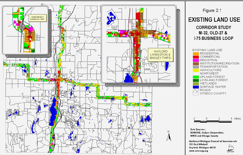
The NEMCOG Geographic Information System was used to produce the maps in this report. The 1994 digital land use polygons were placed over the 1998 digital aerial photo images. These were then modified to reflect the current land use at the time that the aerial photos were taken. The categories of land use were updated using the Michigan Resource Inventory System (MIRIS) classifications. Those classifications were then merged into 11 categories for map display purposes: Residential, Commercial, Industrial, Institution/Recreational, Transportation, Agricultural, Nonforest, Upland Forest, Lowland Forest, Wetlands, and Surface Water. The following descriptions are detailed findings for the entire study area ( ¼ mile either side of Old-27 / I-75BL and M-32). Figure 2.1 depicts the existing land use for the study area.
Residential
Residential land use includes residential dwelling structures such as: single family or duplexes, multi-family low rise residential, multi-family medium & high rise residential, and mobile home
Figure 2.1
Existing Land Use
parks. The total residential land use in the corridor study area is approximately 2,653 acres, or 15.6% of the total. From Center Street in the City of Gaylord, east along M-32, residential land use comprises 697 out of 5,692 acres. West along M-32, residential land use comprises 511 out of 3,618 acres. From M-32 in the City of Gaylord, north along Old-27, residential land use comprises 666 out of 3, 983 acres. South along Old-27 / I-75BL, residential land use comprises 823 out of 3,836 acres.
Commercial
The commercial land use category includes classifications related to the sale of products and services such as: central business districts, shopping centers/malls, strip commercial, and neighborhood compact groups of stores that are surrounded by noncommercial uses. This category includes parking areas related to the commercial businesses. The total commercial land use in the corridor study area is approximately 952 acres, or 5.6% of the total. From Center Street in the City of Gaylord, east along M-32, commercial land use comprises 61 out of 5,692 acres. West along M-32, commercial land use comprises 233 out of 3,618 acres. From M-32 in the City of Gaylord, north along Old-27, commercial land use comprises 211 out of 3,983 acres. South along Old-27 / I-75BL, commercial land use comprises 492 out of 3,836 acres.
Industrial
Industrial land use includes manufacturing and industrial parks, light industries that fabricate or package products, oil & gas drilling and production facilities, lumber mills, chemical plants, brick-making plants, large power facilities, waste product disposal areas, areas of stockpiled raw materials, and transportation facilities that normally handle heavy materials. The total industrial land use in the corridor study area is approximately 462 acres, or 2.7% of the total. From Center Street in the City of Gaylord, east along M-32, industrial land use comprises 97 out of 5,692 acres. West along M-32, industrial land use comprises 162 out of 3,618 acres. From M-32 in the City of Gaylord, north along Old-27, industrial land use comprises 129 out of 3,983 acres. South along Old-27 / I-75BL, industrial land use comprises 77 out of 3,836 acres.
Institution/Recreational
Institution/recreational land use includes a variety of classifications such as education, government, religious, health, correctional, and military facilities, all indoor and outdoor recreational facilities, and all cemeteries. The buildings, parking areas, and immediate grounds are included in this category, however all surface water, forest, barren land, and wetlands associated with these facilities are entered into their own respective categories. The total institution/recreational land use in the corridor study area is approximately 722 acres, or 4.2% of the total. From Center Street in the City of Gaylord, east along M-32, institution/recreational land use comprises 136 out of 5,692 acres. West along M-32, institution/recreational land use comprises 204 out of 3,618 acres. From M-32 in the City of Gaylord, north along Old-27, institution/recreational land use comprises 165 out of 3,983 acres. South along Old-27 / I-75BL, institution/recreational land use comprises 224 out of 3,836 acres.
Transportation
This category includes areas used for road pavements, interchanges, and rights of way. The transportation land use in the corridor study area is approximately 328 acres, or 1.9% of the total. From Center Street in the City of Gaylord, east along M-32, transportation land use comprises 10 out of 5,692 acres. West along M-32, transportation land use comprises 55 out of 3,618 acres. From M-32 in the City of Gaylord, north along Old-27, transportation land use comprises 2 out of 3,983 acres. South along Old-27 / I-75BL, transportation land use comprises 265 out of 3,836 acres.
Agricultural
The agricultural land use category generally includes land that is used for the production of food and fiber, but also includes land used for non-food livestock such as horses. These classes are: cropland, orchards (including vineyards and ornamental horticulture), confined feeding operations for livestock of any kind, permanent pasture lands, farmsteads, greenhouse operations, and horse training areas. The total agricultural land use in the corridor study area is approximately 2,347 acres, or 13.8% of the total. From Center Street in the City of Gaylord, east along M-32, agricultural land use comprises 1,600 out of 5,692 acres. West along M-32, agricultural land use comprises 179 out of 3,618 acres. From M-32 in the City of Gaylord, north along Old-27, agricultural land use comprises 567 out of 3,983 acres. South along Old-27 / I-75BL, agricultural land use is not found.
Nonforest
Nonforest land includes "open land" and rangeland classifications such as barren land, herbaceous open land, and shrubland. Herbaceous open land is usually subjected to continuous disturbance such as mowing, grazing, or burning, and typically it can have a variety of grasses, sedges, and clovers. Shrubland is land in transition from being open to becoming an eventual forest. There are native shrubs and woody plants like blackberry, dogwood, willow, sumac, and tag alder. The nonforest land in the corridor study area is approximately 3,201 acres, or 18.8% of the total. From Center Street in the City of Gaylord, east along M-32, nonforest land comprises 1,089 out of 5,692 acres. West along M-32, nonforest land comprises 785 out of 3,618 acres. From M-32 in the City of Gaylord, north along Old-27, nonforest land comprises 1,073 out of 3,983 acres. South along Old-27 / I-75BL, nonforest land comprises 253 out of 3,836 acres.
Upland Forest
Forest land use areas are generally at least 10% stocked by trees of any size. The upland forest category includes upland hardwoods like maple & beech, other upland species like aspen & birch, species of pine like red, white or jack pine, and other upland conifers like white spruce, blue spruce, eastern hemlock, and balsam fir. Upland forest in the corridor study area is approximately 4,975 acres, or 29.3% of the total. From Center Street in the City of Gaylord, east along M-32, upland forest comprises 1,623 out of 5,692 acres. West along M-32, upland forest comprises 1,438 out of 3,618 acres. From M-32 in the City of Gaylord, north along Old-27, upland forest comprises 837 out of 3,983 acres. South along Old-27 / I-75BL, upland forest comprises 1,077 out of 3,836 acres.
Lowland Forest
Lowland forest areas are dominated by tree species that grow in very wet soils. Lowland hardwoods include ash, elm, soft maple, cottonwood and others. Lowland conifers include cedar, tamarack, black and white spruce, and balsam fir. The lowland forest in the corridor study area is approximately 525 acres, or 3.1% of the total. From Center Street in the City of Gaylord, east along M-32, lowland forest comprises 229 out of 5,692 acres. West along M-32, lowland forest areas are not found. From M-32 in the City of Gaylord, north along Old-27, lowland forest comprises 279 out of 3,983 acres. South along Old-27 / I-75BL, lowland forest comprises 17 out of 3,836 acres.
Wetlands
Wetlands are those areas where the water table is at or near the land surface for a significant part of most years. Examples of wetlands are marshes, mudflats, wooded swamps, shallow areas along rivers or lakes or ponds. Wetlands areas include both non-vegetated mud flats and areas of hydrophytic vegetation. The wetlands category in the corridor study area is approximately 195 acres, or 1.1% of the total. From Center Street in the City of Gaylord, east along M-32, the wetlands category comprises 77 out of 5,692 acres. West along M-32, the wetlands category is not found. From M-32 in the City of Gaylord, north along Old-27, the wetlands category comprises 52 out of 3,983 acres. South along Old-27 / I-75BL, the wetlands category comprises 67 out of 3,836 acres.
Surface Water
The surface water category includes areas such as lakes, reservoirs, ponds, rivers, and streams. Surface water in the corridor study area is approximately 665 acres, or 3.9% of the total. From Center Street in the City of Gaylord, east along M-32, surface water comprises 71 out of 5,692 acres. West along M-32, surface water comprises 50 out of 3,618 acres. From M-32 in the City of Gaylord, north along Old-27, surface water comprises only 1 out of 3,983 acres. South along Old-27 / I-75BL, surface water comprises 542 out of 3,836 acres.
Utility Service Areas

Electric Service Area
Two phase electrical service is available throughout the corridor. Commercial, industrial and high density residential such as multi-family residential require 3-phase electrical service. The presence of 3-phase electric service is one of a number factors that can determine the type and intensity of development. Otsego County has an extensive 3-phase electric service grid, which is likely attributed to oil and gas development during the last twenty years.
Figure 2.2 shows the presence of three phase electrical service in the study corridor. This service is available along most of the corridor except for small segments in eastern Elmira Township, northern Livingston Township and northern Bagley and Chester Townships.
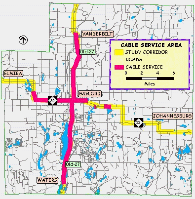
Cable Television Service Area
Cable television service does not drive development pressures and typically is extended into areas where development has already occurred. However, with further advances in technology and the ability for two-way data transmission, wide band-width data transmission of cable service offers some promising possibilities. C-TEC is planning to upgrade the cable network to allow for two-way communication or internet access within the next three years. Cable service is one of a number of factors that can influence the location and type of development.
Figure 2.3 depicts the location of cable service along the study corridor. Cable television service is available along Old 27 between Waters and Vanderbilt, including the City of Gaylord. Service is also available along M-32, from four miles west of Gaylord to approximately two miles east of the City.
Telephone Service Area
Telephone service is available through-out the corridor study area. Fiber optics lines have been run along segments of the corridor. Given current and projected internet usage, access to high speed connections via fiber optics line for homes and businesses will continue to be important. Fiber optic lines are located along Old 27 from Vanderbilt north to the county line, and Gaylord north to Parmater Road, see 2.4.
Fiber optic lines are also located along M-32 from Gaylord east to McCoy Road
and from Douglas Lake Road to the County Line.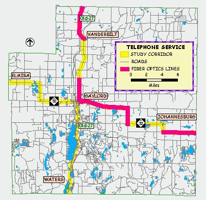
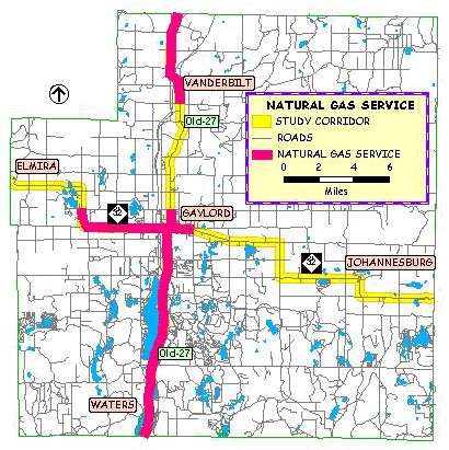
Natural Gas Service Area
Natural gas service is preferred for higher density residential, commercial and industrial development. Service area within the corridor study areas is depicted in Figure 2.5. Natural gas service is available along Old 27, from Bagley Road in Corwith Township north to the county line. The service area includes the City of Gaylord south along Old 27 to the County line. Service along M-32 is from Hallenius Road in Elmira Township east through Gaylord to Krys Road.
Public Water and Sanitary Sewer Service Area
Access to community or public water and sewer service is necessary for large scale commercial and high density residential development. Public water and sewer is available within the City of Gaylord and has been extended to several parcels under 425 agreements. Hidden Valley Resort and associated condominium developments are served under a 425 agreement. Public Act 425 of 1984 allows for a city and township to enter into a "Conditional Transfer of Property" whereby both entities share property tax revenues and jurisdiction prior to the property being annexed into the city. The law allows for agreements of up to 50 years. Typically, this action occurs when development of properties requires services such as public water and sanitary sewer that the township can not provide. Bagley Township intends to develop a public water and sewer system to serve the newly established
DDA. The provision of sanitary sewer into other parts of the Township and possibly around Otsego Lake is also being considered.
Figures 2.6 and 2.7 show the locations of existing public water and sanitary sewer service areas.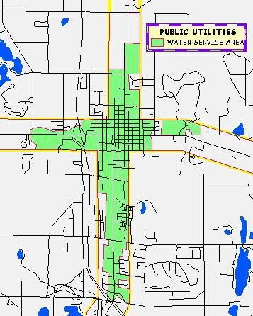

Off Site Advertising
The location of billboards along state and federal highways is governed by state laws. State law regulates the spacing, size and location of off-site advertising signs. Local communities can choose to regulate both on-site and off-site signage on all roadways. Furthermore, communities can adopt regulations governing billboards along state and federal highways that are more stringent than the state law. The location of billboards are shown on Figure 2.8.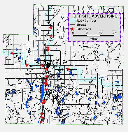
DDA Districts
There are two Downtown Development Authorities (DDA) in the study area. Bagley Township established a DDA in 1999 and adopted a Development Plan and Tax Increment Financing Plan in January of 2000. The City of Gaylord established a DDA in 1989 and adopted a Tax Increment Financing and Development Plan in 1991.
Figure 2.9 shows the location of DDA districts within the corridor study area. The purpose of DDA's is to establish the legal basis and
procedure for use of tax increment revenues in accordance with Public Act 197 of 1975. The revenues are used to make infrastructure improvements within the district. These may include streetscaping, roads, sidewalks, and water and sanitary sewer service.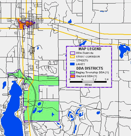
The Bagley Township DDA district is located adjacent to the south Business I-75 interchange. The approximate boundaries are Old 27, Charles Brink Road, Krys Road and Johnson Road. The boundary extends north of Johnson Road approximately 1,320 feet and around the intersection of Dickerson Road and North Otsego Lake Drive. The proposed future uses within the corridor study area are Light Industrial/High Technology, Regional Shopping and Entertainment, General Business and Resort Recreation. Of particular interest is the proposed regional shopping center adjacent to the interchange. The shopping center will be a significant transportation generator and result in increased traffic volumes along the corridor. A traffic impact study has been completed and considerable "up-front" planning is occurring to mitigate the impacts of increased traffic volumes.
Visual Resources and Community Character
The visual resources within the study area are rich and varied ranging from the downtown of Gaylord with an alpine architectural motif to the rolling farmlands near Johannesburg; the lakeside resort/residential areas and the pine and hardwood forests. People traveling through the area are left with images of rolling hills, forests and farms, lakeside homes, parks and the lively and unique downtown business area of Gaylord. The Village of Vanderbilt is working towards changing it's image by constructing parks, seeking funding to revitalize homes and businesses, and removing blighted buildings that crowd the main crossroads of Old 27 and Sturgeon Valley Road. The eastern M-32 entryway into Gaylord runs through an older residential neighborhood of large homes and mature urban forests. The large towering trees, while providing shade and beauty to the homes and roadway, also tend to function as traffic calming features slowing traffic entering the city. Other entryways into the City tend to be less attractive and are typical of strip commercial highway developments, designed to service cars, not pedestrians. Large parking lots in front of buildings, numerous access points, minimal landscaping, absence of street trees, business signs, and large utilities poles add up to visual clutter.
The four legs of the corridor study area have distinct regional landscape features. West M-32, from Elmira to Gaylord, can be characterized by pine and maple forests, interspersed with old farm fields, summer recreation camps and small lakes. Residential and commercial development becomes more prevalent closer to Gaylord. A segment of the highway that meanders between several lakes breaks the monotony of straight stretches and offers glimpses of the small kettle hole lakes. The study area east of Gaylord can be characterized by rolling farmland and northern hardwood forests. The hills and valleys provide an ever changing array of views for the traveler. M-32 passes through the unincorporated community of Johannesburg, part of Charlton Township. This community was once a thriving lumber town. Today, it is a bedroom community of Gaylord with a few businesses, Charlton Township Hall and the Johannesburg-Lewiston school complex functioning as the center of community life.
Old 27 North from the county line to Gaylord passes through old farm fields and hardwood forests. Low density residential development prevails. The roadway passes through the Village of Vanderbilt after crossing over the I-75 freeway. Along with constructing small parks, the Village is working to improve the image of the community by addressing the issue of blighted buildings. Between Vanderbilt and Gaylord, the terrain is rolling and the landscape can be characterized by farms and hardwood forests. Wetlands associated with headwater creeks of the Sturgeon River cross the corridor. Ironton Springs roadside park offers a quiet rest stop and picnic area. Larger estate size homes can be found north of Gaylord.
The southern leg of the corridor, Old 27 from the south county line to Gaylord is quite unlike other segments of the study area. The roadway traverses oak and aspen forests, passing by many inland lakes, like Otsego, Dodge, Hatch, Heart, Big Bradford, and Marjory Lakes. This segment can be characterized by lakeside resort-residential development and highway commercial development in Waters and Bagley Township. Lake State Railroad corridor parallels Old 27, between Waters and the south Gaylord I-75 interchange, limiting access and development along the west side of the roadway.