Introduction
Background
Otsego County in the past few decades has experienced dramatic growth in the residential, commercial, and industrial sectors. The area has grown from primarily a small town/rural setting to an area bustling with commercial, industrial, and residential growth, particularly in and around the City of Gaylord. The population grew by 38.1 percent between 1960 and 1970 and by 43.9 percent between 1970 and 1980. The population increased by 19.8 percent from 1980 to 1990. From 1990 to 2000, the population increased by an estimated 21.9 percent, making Otsego County the second fastest growing county (percentage wise) in the entire State. As shown in Table 1.1 these trends are expected to continue to the year 2020. Employment projections indicate a similar trend, with projections showing employment increasing by 1000 jobs every five years.
|
Table 1.1 Otsego County, Population Projections: 2000 - 2020 |
||||||
|
Source |
2000 |
% Change 1990-2000 |
2010 |
% Change 2000-2010 |
2020 |
% Change 2010- 2020 |
|
NEMCOG |
21,886 |
+21.9% |
26,862 |
+22.7% |
N/A |
N/A |
|
U of M |
22,203 |
+23.6% |
24,439 |
+10.1% |
26,134 |
+6.9% |
|
DMB |
23,200 |
+29.2% |
28,500 |
+22.8% |
34,800 |
+22.1% |
Source: NEMCOG - by Northeast Michigan Council of Governments; U of M - Regional Economic Models, Inc. by University of Michigan for the Michigan Department of Transportation; DMB - Michigan Department of Management and Budget, Office of the State Demographer.
Urban land uses are expanding outward from the City of Gaylord east and west along M-32, as well as north and south along Old27/I-75 Business Loop. Strip commercial development is most prevalent on M-32 west and the I-75 business loop. High numbers of access points, large parking lots, above ground utilities and a lack of street trees and landscaping present an unattractive appearance to these segments of the corridors. Heavy traffic volumes associated with local business activity and area-wide tourism activity result in congestion and traffic safety problems. This is most apparent in the parts of Gaylord and Livingston, Bagley and Otsego Lake Township's.
Historically, coordinated planning, that combines land use and transportation planning, has been minimal at the local level. Local communities have recognized the need to develop new policies and guidelines. It is essential that proactive and remedial measures be incorporated at the local level to prevent further traffic congestion, to address safety issues, and to provide for the long-term sustainability of the area’s local economy.
Several years ago, the Otsego County Coordinated Land Use Committee was organized through the Northeast Michigan Council of Governments (NEMCOG). The committee has been meeting to address the escalating transportation problems and related land use issues occurring as a result of the rapid growth in Otsego County. Representation on this committee includes: Otsego County Road Commission, Otsego County Board of Commissioners, Otsego County Planning Commission, City of Gaylord, Michigan Township Association, MSU Extension, and NEMCOG. With the addition of new members representing Village of Vanderbilt, Michigan Department of Transportation and local businesses, the Coordinated Land Use Committee provided oversight and input throughout the course of the study and provided communication to their constituents as the plan was drafted.
This Corridor study was funded by a grant and with local match. The Northeast Michigan Council of Governments (NEMCOG) received a $65,000 grant from the Michigan Department of Transportation to prepare the corridor study. Gaylord, Vanderbilt, Otsego County, Townships, Otsego County Road Commission and the Northeast Michigan Council of Governments provided $14,600 in local match. NEMCOG staff, with the assistance of Wade-Trim, Inc. provided technical support and facilitated the study process and plan development.
Study Area
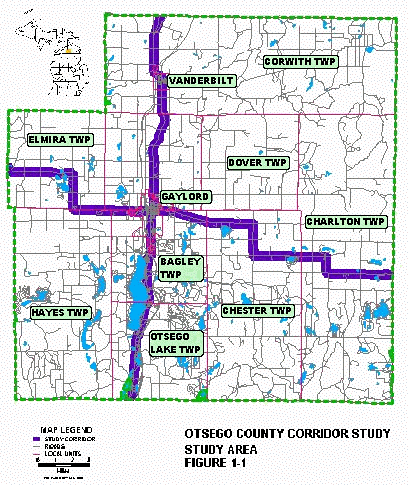
The corridor study area involves eleven local units of governments including: Otsego County, the City of Gaylord, the Village of Vanderbilt, Elmira Township, Livingston Township, Bagley Township, Otsego Lake Township, Hayes Township, Corwith Township, Chester Township, and Charlton Township. For study purposes, the corridor is defined as an area that lies ¼ of a mile to either side of M-32 and Old 27/Business I-75. Where appropriate, land use activity outside the corridor will be considered, however, the primary focus of the study will be the identified 1/2 mile wide corridor. Figure 1.1 depicts the corridor study area.
Planning activity is occurring at county, city and village level. Otsego County and Gaylord have completed master plan updates within the last six years. The Village of Vanderbilt is in the process of updating their master plan. Several townships have active planning programs, for example Livingston Township developed a master plan and a growth management forum in the
mid 90's and Bagley Township has recently completed a DDA plan. Zoning is administered at the county level, excluding the City of Gaylord and the Village of Vanderbilt which each administer their own zoning ordinance.
Purpose of the Planning Process
The purpose of the M-32/Old 27/Business I-75 Corridor Study is to provide guidelines for managing growth and development along these priority transportation corridors in Otsego County. First, the study will identify and analyze existing conditions such as land use, zoning, environmental conditions, utility service areas, traffic volume data, crash data, and local planning and zoning activity. Next, the study will develop recommendations to maintain safety, carrying capacity and visual quality. The recommendations will be based on goals defined by the communities. The study will be compiled into a corridor plan, including access management standards, that addresses land use compatibility and development standards, and model zoning ordinance language for access management, billboards, signs, stormwater management and aesthetics.
It is the intent of this planning process to develop policies and guidelines to facilitate a coordinated approach to land use planning and transportation planning. Adoption of the plan as a master plan amendment will enable communities to use the policies and guidelines in their day to day planning activities. The adoption process should follow procedures defined in the township, village, city and county planning statutes respectively. Adoption of the plan will serve as the legal foundation for regulating land use activity along the corridor through zoning.