Improvement Strategies & Recommendations
Based on goals, objectives, observations and ideas of the Corridor Study Committee, existing and projected roadway operating conditions, existing and projected traffic conditions, and current literature on safety and design alternatives, the following recommendations are listed to satisfy goals and objectives of the study. Note: The following recommendations were developed by consensus of the committee members. Present constraints such as existing right-of-ways, funding, and agency/department policy were considered, but these constraints were not the only factors considered when developing the recommendations. Since this plan covers a ten to twenty year planning horizon, it is acknowledged these present constraints will likely change over time.
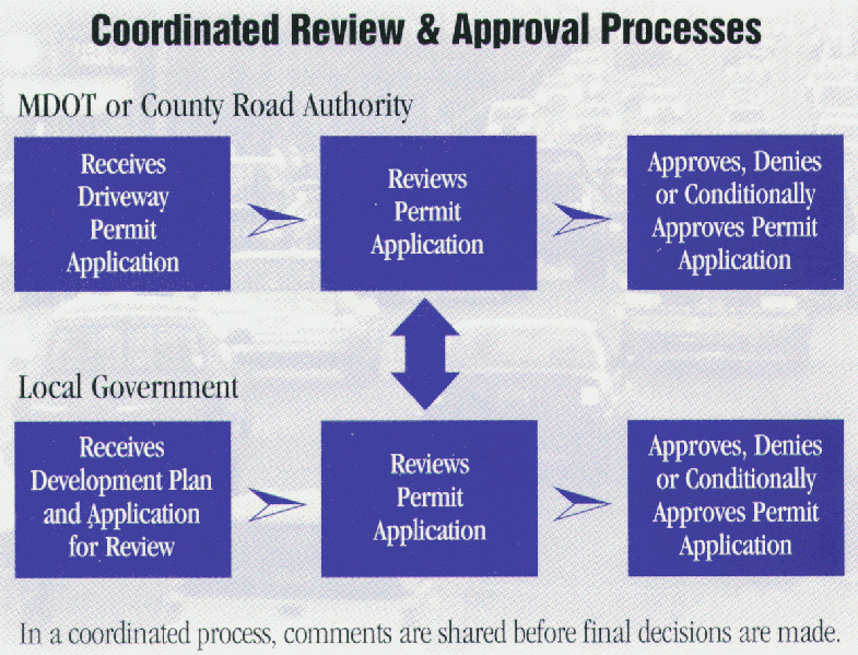
Recommendation 1: Communication
The Corridor Study Committee participants should continue to meet periodically to discuss progress on achieving goals and objectives of this study. Only continued communication can ensure that all of the necessary agencies and departments are working toward specific goals at the same time. Good communication between agencies, planning commissions, local governments, and schools is especially important during new development, as access management issues occur. A checklist form with a flowchart describing steps for development should be available for developers. The appropriate planning commission(s), and the Road Commission and/or MDOT (as appropriate), should reach consensus on the placement of access driveways before building permits are issued for new construction.
Recommendation Group 2: Medians, Turning Lanes, Passing Flares
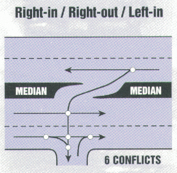
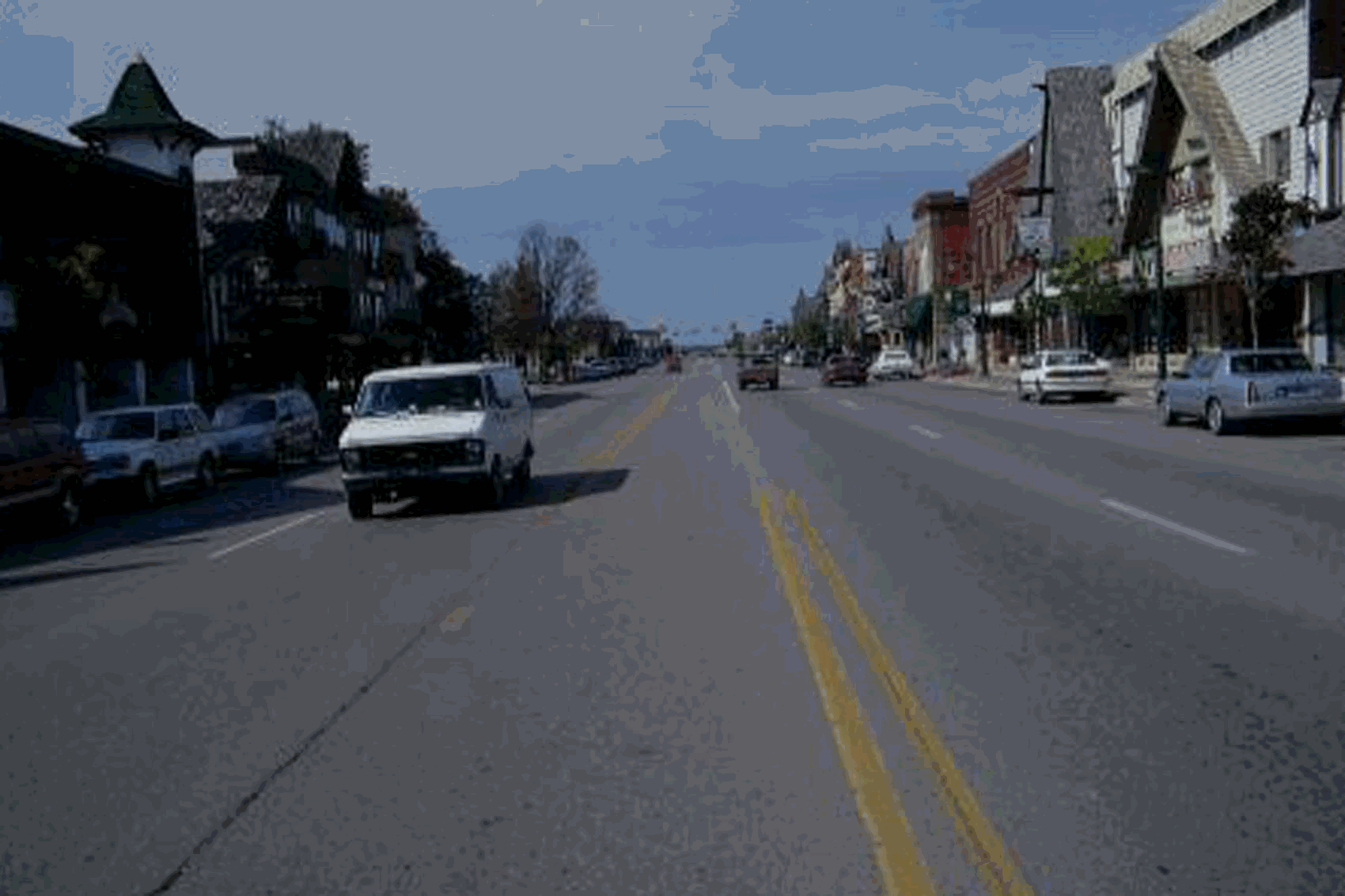
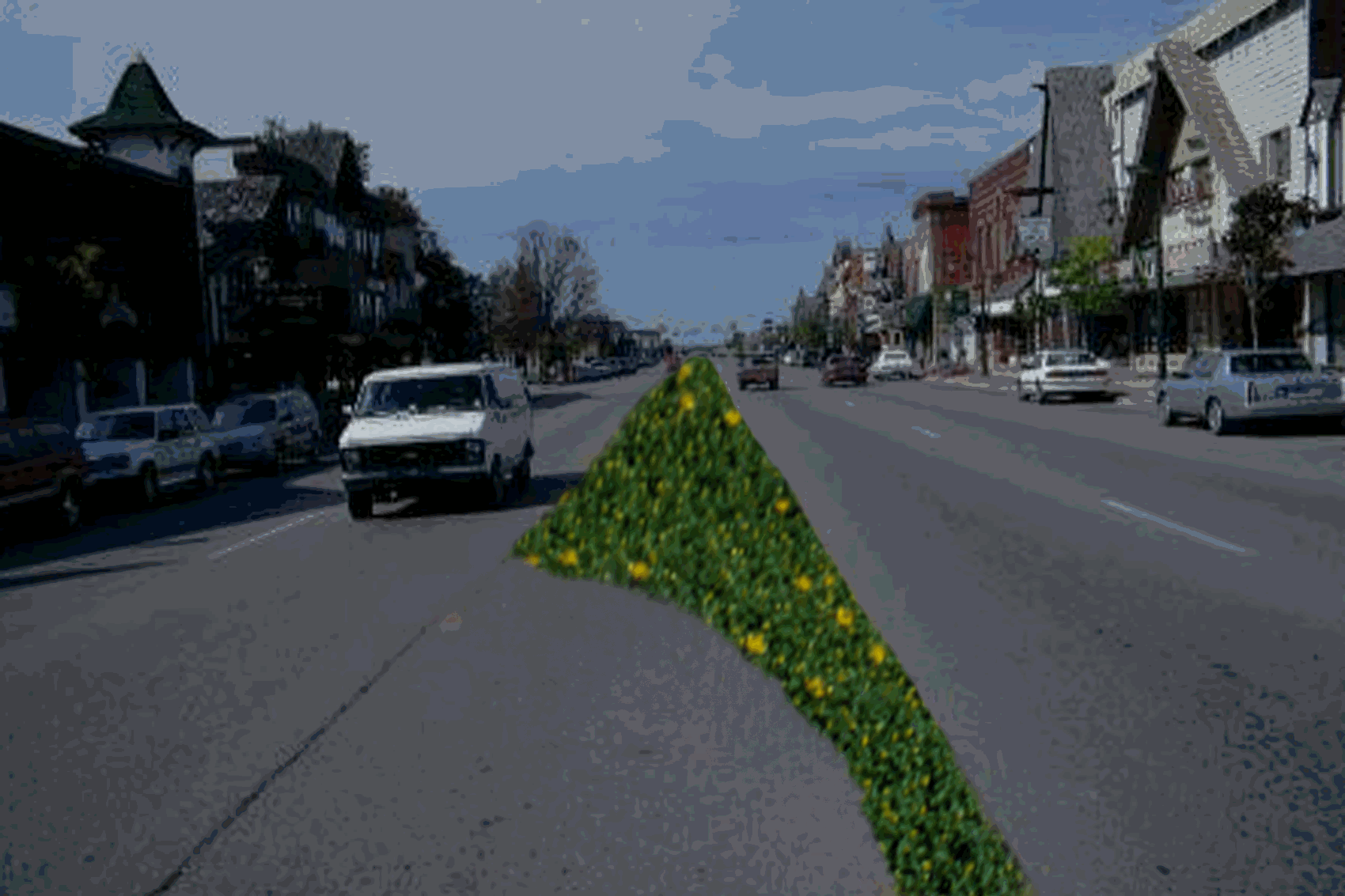
The installation of raised medians in place of the two-way-left-turn-lanes (TWLTL) should be studied in the urbanized segments of the M-32 and Old-27/I-75 BL corridors. Medians are a way to separate opposing traffic, channel the movements of traffic, and reduce the left turning movements of vehicles for safety reasons and for ease of driving.
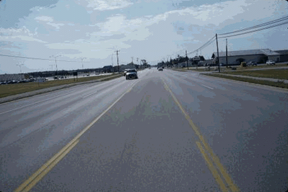
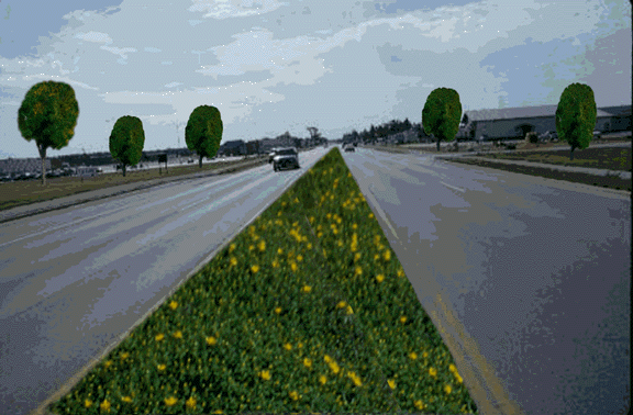
The current roadscape on the right, and shown on the left as it can look with a green center median, buried power lines, and with trees.
Left turnouts and right turn lanes should be placed where necessary to remove local destination traffic from the through lanes. Right ‘passing flares’ (a lane on the shoulder) should be provided where possible so that through vehicles may continue past a left turning vehicle.
Provisions should be made to lengthen the left turn lane storage on M-32 at the northbound I-75 ramp.
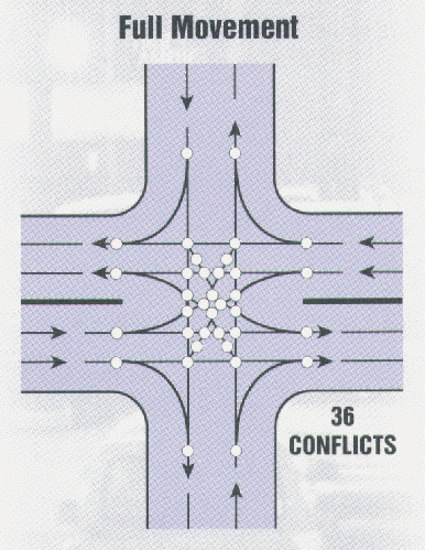
A study should be conducted to explore possible access alternatives to alleviate peak period traffic congestion at Livingston Boulevard and Old-27 North. Alternatives may include, but not be limited to: a second ingress/egress point to the north of the existing access, a traffic signal installed at the intersection of Livingston Boulevard and Old-27 North, a center median on Old-27 North to channel traffic flow and reduce left turning movements, or a roundabout located at that intersection to ensure that only right turns are made. A sufficient right-of-way exists (200’) to allow the flexibility to explore many design options.
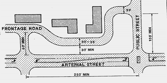
Recommendation Group 3: Access Driveways, Frontage Roads, Rear Access Drives, Parking, Informational Sessions
Access driveways should be limited, at minimum, to the spacing as recommended in the access management section (Chapter 6) of this report, through the use of frontage roads, rear access drives, shared driveways, and shared parking facilities.
Businesses should be required to share driveways & parking facilities. Parking facilities should be required to have good internal circulation designs to minimize conflicts with pedestrians and other vehicles.
New businesses should be issued temporary driveway permits with the understanding that a frontage road or rear access drive will be required as neighboring businesses develop. Businesses should be required to have driveway access permits before building permits are issued.
In areas of existing strip development with open access & parking lots, redevelopment requirements should stipulate that parking will be moved to the side or rear of buildings, and direct access will be limited to that as recommended in the access management section (chapter 6) of this report.
Informational sessions on access management should be held with local retailers, realtors, and builders associations.
The closely spaced driveways along M-32 within the City of Gaylord should be moved to the rear as redevelopment occurs.
Pineview Road should be constructed to extend behind the Home Depot to an extended McVannel Road, to be available as a rear access drive with sufficient right-of-way for recreational uses.
Recommendation Group 4: Pedestrian and Bicycle Facilities
The City of Gaylord and County of Otsego should continue to pursue the planned bicycle and pedestrian trail system which will connect points of interest throughout the corridor study area, such as: parks and recreation areas, commercial shopping districts, residential developments, and community centers.
Bicycle lanes should be provided both on and off the right-of-way where possible.
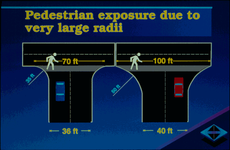
Pedestrian crosswalk distances should be kept as short as possible through the use of ‘bulbouts’, medians, median islands, and shorter driveway turning radii.
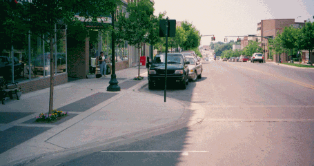
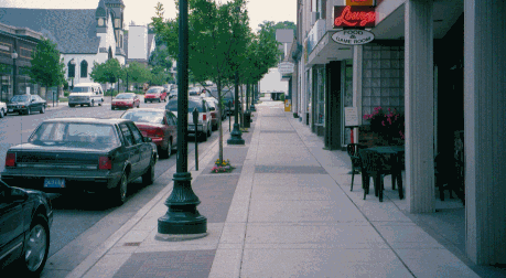
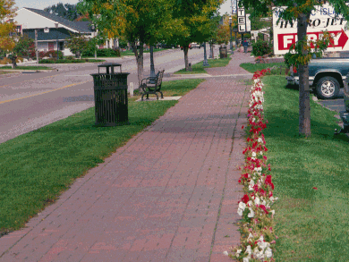
Green buffers and sidewalks should be provided along the urban and suburban segments of the roadway.

Pedestrian facilities in Petoskey and Mackina
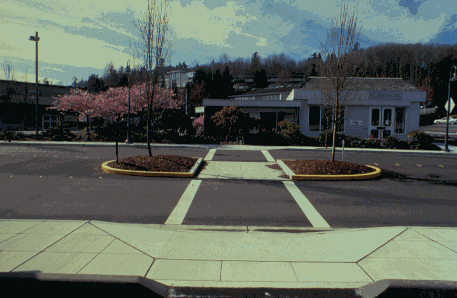
Pedestrian mid-block crossings should be clearly marked, and should include a ‘safe haven’ abbreviated median halfway across.
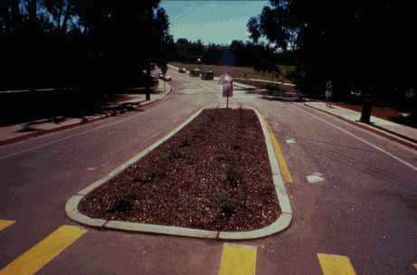
Good examples of pedestrian crossings: San Luis Obispo, California and
Mercer Island, Washington
Recommendation Group 5: Increasing The Economic Viability Of Downtown Areas And New Developments
To increase the opportunity for motorists to notice and stop at downtown businesses, physical techniques should be used to calm traffic, such as green buffers with sidewalks, landscaping, median islands, and tree plantings in a center median.
The traffic signal delay impacts at intersections should be minimized by setting the phase timing to maximize roadway capacities.
An alternate route for M-32 through traffic in the City of Gaylord should be studied. The route may include construction of an overpass of I-75 in alignment with McCoy Road. The study should focus on improvement or upgrading of the existing roadway network to the maximum extent feasible. The study should provide forecasted volumes, impacts and benefits, and cost estimates for the various alternatives including the "do nothing" alternative. Benefits to the local road network and state road network should be identified. The study should include project financing recommendations and suggested funding responsibility by agency based on benefit derived.
Informational sessions on access management should be held with business interests.
A traffic impact study is recommended for proposed new development in Vanderbilt. Also, Vanderbilt’s efforts to reduce the blight of dilapidated buildings at the corners of Old-27 and Main Street/Sturgeon Valley Road should continue.
As a result of recent traffic impact studies, it is recommended that right-of-way should be purchased, if necessary, for the possible new locations of N. Otsego Lake Drive at Old-27 South, and the northwest I-75 ramps at Old-27 South. These new locations may be necessary to accommodate future growth and development of the I-75 interchange area.
The City of Gaylord and the County of Otsego, together, should plan locations that are best suited for future growth. The need and location of future streets and roads associated with designated future growth areas should be identified during these planning sessions.
Recommendation Group 6: Aesthetics, Recreation and Natural Resources
New developments should be required to have a green buffer or landscaping to minimize view impacts.
Within older and new commercial highway development areas, such as M-32 west and Business I-75, utility lines should be buried instead of placed on poles. This practice will soften the visual impacts of development and will allow for planting of street trees and other landscape features.
Local zoning ordinances should be examined to ensure adequate signage and billboard controls.
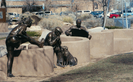
Landscaping and works of art in urbanized segments of the corridor should be used to beautify the communities. Landscaping can be both within green medians and along the roadways as a buffer for sidewalks.
Snowmobile and other recreational vehicle trails should be established outside of the corridor study area, with adequate signage and posted speed limits. Designated crossings and parking areas should be provided for recreational vehicles at points along the M-32 and Old-27corridors.
More parks and recreational areas should be established along the corridors.
Open space should be preserved by making it ‘easier’ to build conservation, cluster-type developments, than to build standard subdivisions. This open space preservation can include farm land, forest land, open fields, and wetlands.
Recommendation Group 7: Community Planning
All jurisdictions within the study area should adopt the M-32, Old 27 & Business I-75 Corridor Plan.
All jurisdictions along the corridor should adopt/amend land use plans, zoning and access management
regulations that are compatible with the corridor plan recommendations.
A joint planning commission meeting with the city, village, township and county planning commissions should be held annually to discuss cross-jurisdictional issues.
Jurisdictions should incorporate recommendations into their capital improvement programming process.